
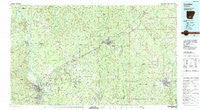
~ Camden AR topo map, 1:100000 scale, 30 X 60 Minute, Historical, 1986, updated 1986
Camden, Arkansas, USGS topographic map dated 1986.
Includes geographic coordinates (latitude and longitude). This topographic map is suitable for hiking, camping, and exploring, or framing it as a wall map.
Printed on-demand using high resolution imagery, on heavy weight and acid free paper, or alternatively on a variety of synthetic materials.
Topos available on paper, Waterproof, Poly, or Tyvek. Usually shipping rolled, unless combined with other folded maps in one order.
- Product Number: USGS-5429772
- Free digital map download (high-resolution, GeoPDF): Camden, Arkansas (file size: 28 MB)
- Map Size: please refer to the dimensions of the GeoPDF map above
- Weight (paper map): ca. 55 grams
- Map Type: POD USGS Topographic Map
- Map Series: HTMC
- Map Verison: Historical
- Cell ID: 67214
- Scan ID: 260395
- Imprint Year: 1986
- Woodland Tint: Yes
- Aerial Photo Year: 1982
- Edit Year: 1986
- Datum: NAD27
- Map Projection: Universal Transverse Mercator
- Map published by United States Geological Survey
- Map Language: English
- Scanner Resolution: 600 dpi
- Map Cell Name: Camden
- Grid size: 30 X 60 Minute
- Date on map: 1986
- Map Scale: 1:100000
- Geographical region: Arkansas, United States
Neighboring Maps:
All neighboring USGS topo maps are available for sale online at a variety of scales.
Spatial coverage:
Topo map Camden, Arkansas, covers the geographical area associated the following places:
- Warren - Bests (historical) - Onalaska (historical) - Lufra (historical) - Watson - Tipton - Draughon (historical) - Van Wagoner (historical) - Hampton - Kent - Jackson (historical) - Toledo - East Camden - McKinney - Cloquet (historical) - Levit (historical) - Mount Elba - Mason (historical) - Cruse (historical) - New Hope - Vanduzer - Lacy (historical) - Smead - Ivan - Draper (historical) - Locust Bayou - Wise (historical) - Camden - Cullendale - Banks - Woodberry - Forrest Bonner - Carmel - Elberta (historical) - Oakhurst (historical) - Chambersville - Saline - Camark - Sparkman - Bucksnort - Smead (historical) - Craney - Herbine - Kemp (historical) - Big Hill - Friendship - Jacinto - Little Bay - Lunet - Lanark - North Fordyce - Orlando - Rison - Oak Grove - Lilley (historical) - McKinney (historical) - Blue Springs (historical) - Rendezvous - Harbour (historical) - New Edinburg - Bearden - Ramsey - Pine Grove - Rowell - Gum Springs - Harrell - Eagletie - Millville - Velie - Heine (historical) - Sneed (historical) - Tates Bluff - Salem - Cross Roads - Beech Grove - Shumaker - Fairview - Como (historical) - Dwight (historical) - Trigg (historical) - Oak Grove - Glynn (historical) - Lakeside - Green Hall (historical) - Kingsland - Fairview - Meek (historical) - Princeton - Calmer - Weeks - Ellisville - Ebenezer - Hebron (historical) - Tinsman - Thornton - Lindale (historical) - Pansy - Ripley (historical) - Harlow - Herbert
- Map Area ID: AREA3433.5-93-92
- Northwest corner Lat/Long code: USGSNW34-93
- Northeast corner Lat/Long code: USGSNE34-92
- Southwest corner Lat/Long code: USGSSW33.5-93
- Southeast corner Lat/Long code: USGSSE33.5-92
- Northern map edge Latitude: 34
- Southern map edge Latitude: 33.5
- Western map edge Longitude: -93
- Eastern map edge Longitude: -92


