
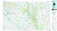
~ Brinkley AR topo map, 1:100000 scale, 30 X 60 Minute, Historical, 1990, updated 1991
Brinkley, Arkansas, USGS topographic map dated 1990.
Includes geographic coordinates (latitude and longitude). This topographic map is suitable for hiking, camping, and exploring, or framing it as a wall map.
Printed on-demand using high resolution imagery, on heavy weight and acid free paper, or alternatively on a variety of synthetic materials.
Topos available on paper, Waterproof, Poly, or Tyvek. Usually shipping rolled, unless combined with other folded maps in one order.
- Product Number: USGS-5429768
- Free digital map download (high-resolution, GeoPDF): Brinkley, Arkansas (file size: 24 MB)
- Map Size: please refer to the dimensions of the GeoPDF map above
- Weight (paper map): ca. 55 grams
- Map Type: POD USGS Topographic Map
- Map Series: HTMC
- Map Verison: Historical
- Cell ID: 67185
- Scan ID: 260393
- Imprint Year: 1991
- Woodland Tint: Yes
- Aerial Photo Year: 1988
- Edit Year: 1990
- Datum: NAD27
- Map Projection: Universal Transverse Mercator
- Map published by United States Geological Survey
- Map Language: English
- Scanner Resolution: 600 dpi
- Map Cell Name: Brinkley
- Grid size: 30 X 60 Minute
- Date on map: 1990
- Map Scale: 1:100000
- Geographical region: Arkansas, United States
Neighboring Maps:
All neighboring USGS topo maps are available for sale online at a variety of scales.
Spatial coverage:
Topo map Brinkley, Arkansas, covers the geographical area associated the following places:
- Super (historical) - Humnoke - Spear (historical) - Tower Hill Addition - Culler - Beecher (historical) - Aberdeen - Peppers Lake - Deep Elm - Hickory Plains - Ragtown - Brasfield - Fairmount - Slovak - Letchworth - Old Austin - Talbot Addition - Brummitt - Boyd (historical) - Butlerville - Saulsburg - Whisperwood - Raymond (historical) - Postelle - Meto - Roe - Parham (historical) - Evergreen Place - Bayou Meto - Allport - Geridge - Hamilton - Biscoe - Shady Grove Estates - Harrys - Lonoke - Coy - Goodwin - Thomas (historical) - Allendale - Blossom - Wattensaw - Windwood Circle - Eagle Park (historical) - Plunketts - Fargo - Jeffries - Sellers Addition - Park Grove - Cooper Addition - Screeton - Confederate Place - Brinkley - Bay Plantation - Stagecoach Addition - Monroe - Pershing Addition - Vise Addition - Burma (historical) - Casscoe - B B Junction - Stuttgart - Sisemore - Harrys (historical) - Tomberlin - Mount Springs Estates - Whispering Pines Addition - Posey - Parkers Corner - Zent - Brownsville - Leaning Pines - Lenoir (historical) - Tarnceville - Seaton - Prairie Center - Lookout - Rich - Ryan - Leighton (historical) - Blakemore - Shadow Oaks Addition - Gospoda - Garrett Grove - Dagmar - Woodlawn Estates - Dobbs Landing - Crossroad - Carlisle - Smale - Poage Addition - Buckhorn - Eden - Ona (historical) - North Stuttgart - Southwood Addition - Hopper - Wheatley - Barrettsville - Tollville
- Map Area ID: AREA3534.5-92-91
- Northwest corner Lat/Long code: USGSNW35-92
- Northeast corner Lat/Long code: USGSNE35-91
- Southwest corner Lat/Long code: USGSSW34.5-92
- Southeast corner Lat/Long code: USGSSE34.5-91
- Northern map edge Latitude: 35
- Southern map edge Latitude: 34.5
- Western map edge Longitude: -92
- Eastern map edge Longitude: -91


