
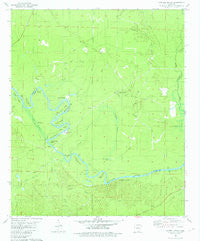
~ Harrell Brake AR topo map, 1:24000 scale, 7.5 X 7.5 Minute, Historical, 1981, updated 1981
Harrell Brake, Arkansas, USGS topographic map dated 1981.
Includes geographic coordinates (latitude and longitude). This topographic map is suitable for hiking, camping, and exploring, or framing it as a wall map.
Printed on-demand using high resolution imagery, on heavy weight and acid free paper, or alternatively on a variety of synthetic materials.
Topos available on paper, Waterproof, Poly, or Tyvek. Usually shipping rolled, unless combined with other folded maps in one order.
- Product Number: USGS-5426592
- Free digital map download (high-resolution, GeoPDF): Harrell Brake, Arkansas (file size: 8 MB)
- Map Size: please refer to the dimensions of the GeoPDF map above
- Weight (paper map): ca. 55 grams
- Map Type: POD USGS Topographic Map
- Map Series: HTMC
- Map Verison: Historical
- Cell ID: 19401
- Scan ID: 258669
- Imprint Year: 1981
- Woodland Tint: Yes
- Aerial Photo Year: 1976
- Edit Year: 1981
- Field Check Year: 1977
- Datum: NAD27
- Map Projection: Lambert Conformal Conic
- Map published by United States Geological Survey
- Map Language: English
- Scanner Resolution: 600 dpi
- Map Cell Name: Harrell Brake
- Grid size: 7.5 X 7.5 Minute
- Date on map: 1981
- Map Scale: 1:24000
- Geographical region: Arkansas, United States
Neighboring Maps:
All neighboring USGS topo maps are available for sale online at a variety of scales.
Spatial coverage:
Topo map Harrell Brake, Arkansas, covers the geographical area associated the following places:
- Lloyd Ford - Lock and Dam Number 8 - Big Swamp Ridge - Harvin Ridge - Stow Lake - Mill Creek Bend - Salt Spring Bend - Bangs Landing - Yellow Bluff - Brann School - McClendon Branch - Gilbert Ridge - Ebenezer School - Cypress Creek Oil Field - Stow Landing - Hurricane Creek - John Mack Slough - Miller Cemetery - Grapevine Lake - Yellow Bluff Bend - Tatum Cemetery - Mill Creek - Tuckers Camp (historical) - Grapevine Bend - Stick Bend - Crooked Slough - Harrell Brake - Buckhorn Branch - Ouachita River Reservoir - Bell Ginhouse Bend - Lewter Creek - Wilmington Oil and Gas Field - McCain Slough - Lloyd Creek - Lock and Dam Number Eight - Highbank Branch - Wilmington Landing - Dutch Bend - Lock Bend - Beulah Springs School - Harrell Branch - Cypress Creek - Birdseye Slough - Crooked Slough Bend - Township of Fayette (historical) - Calion Lock and Dam - Jones Bayou - Wolf Branch
- Map Area ID: AREA33.37533.25-92.5-92.375
- Northwest corner Lat/Long code: USGSNW33.375-92.5
- Northeast corner Lat/Long code: USGSNE33.375-92.375
- Southwest corner Lat/Long code: USGSSW33.25-92.5
- Southeast corner Lat/Long code: USGSSE33.25-92.375
- Northern map edge Latitude: 33.375
- Southern map edge Latitude: 33.25
- Western map edge Longitude: -92.5
- Eastern map edge Longitude: -92.375


