
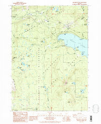
~ Willamette Pass OR topo map, 1:24000 scale, 7.5 X 7.5 Minute, Historical, 1986, updated 1986
Willamette Pass, Oregon, USGS topographic map dated 1986.
Includes geographic coordinates (latitude and longitude). This topographic map is suitable for hiking, camping, and exploring, or framing it as a wall map.
Printed on-demand using high resolution imagery, on heavy weight and acid free paper, or alternatively on a variety of synthetic materials.
Topos available on paper, Waterproof, Poly, or Tyvek. Usually shipping rolled, unless combined with other folded maps in one order.
- Product Number: USGS-5422822
- Free digital map download (high-resolution, GeoPDF): Willamette Pass, Oregon (file size: 12 MB)
- Map Size: please refer to the dimensions of the GeoPDF map above
- Weight (paper map): ca. 55 grams
- Map Type: POD USGS Topographic Map
- Map Series: HTMC
- Map Verison: Historical
- Cell ID: 49120
- Scan ID: 282100
- Imprint Year: 1986
- Woodland Tint: Yes
- Aerial Photo Year: 1983
- Edit Year: 1986
- Field Check Year: 1985
- Datum: NAD27
- Map Projection: Lambert Conformal Conic
- Provisional map: Yes
- Map published by United States Geological Survey
- Map Language: English
- Scanner Resolution: 600 dpi
- Map Cell Name: Willamette Pass
- Grid size: 7.5 X 7.5 Minute
- Date on map: 1986
- Map Scale: 1:24000
- Geographical region: Oregon, United States
Neighboring Maps:
All neighboring USGS topo maps are available for sale online at a variety of scales.
Spatial coverage:
Topo map Willamette Pass, Oregon, covers the geographical area associated the following places:
- Hidden Lake - Shelter Cove Resort Marina - Fuji Creek - Maiden Peak Saddle - Pretty Lake - Roosevelt Point - Rosary Creek - Bechel Creek - Pulpit Rock - Trapper Creek Recreation Site - Trapper Creek Boat Ramp - Engineer Creek - Fawn Lake - Shelter Cove Boat Ramp - Princess Creek Recreation Site - McLeod Creek - Stag Lake - Rankins Horse Pasture - Jungle Creek - Rosary Lakes - Serenity Bay - Eagle Rock - Odell Lake - Abernethy - Abernethy Lake - Dreadnought Island - Midnight Lake - Westview Shelter - Middle Rosary Lake - Yoran Lake - Redtop Mountain - Lils Lake - Upper Marilyn Lake - Marilyn Lakes - Willamette Pass - Riggs Meadow - West Bay - Eagle Peak - Yoran Lake Trail - Pebble Bay Recreation Site - Pengra Pass - Willamette Pass Ski Area - Bonnie Lake - Mule Prairie - Timberline Lake - Trapper Creek - Lakeview Mountain - Junco Creek - Diamond View Lake - Karen Lake - Windfall Creek - Deer Creek - Diamond Peak Wilderness - Shelter Cove - Saddle Lake - North Rosary Lake - Waldo Lake Sno-park - Sow Bug Lake - Lower Marilyn Lake - Pebble Bay - Princess Creek Campground Boat Ramp - Arrowhead Lake - Princess Creek - Gold Lake Sno-Park - Construction Creek - Crystal Creek - Fawn Lake Way - Breezy Point - Cascade Summit Post Office (historical) - Cascade Summit - Bills Creek - Burley Bluff - West Bay Creek
- Map Area ID: AREA43.62543.5-122.125-122
- Northwest corner Lat/Long code: USGSNW43.625-122.125
- Northeast corner Lat/Long code: USGSNE43.625-122
- Southwest corner Lat/Long code: USGSSW43.5-122.125
- Southeast corner Lat/Long code: USGSSE43.5-122
- Northern map edge Latitude: 43.625
- Southern map edge Latitude: 43.5
- Western map edge Longitude: -122.125
- Eastern map edge Longitude: -122


