
~ Whiskey Mountain OR topo map, 1:24000 scale, 7.5 X 7.5 Minute, Historical, 1990, updated 1990
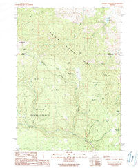
Whiskey Mountain, Oregon, USGS topographic map dated 1990.
Includes geographic coordinates (latitude and longitude). This topographic map is suitable for hiking, camping, and exploring, or framing it as a wall map.
Printed on-demand using high resolution imagery, on heavy weight and acid free paper, or alternatively on a variety of synthetic materials.
Topos available on paper, Waterproof, Poly, or Tyvek. Usually shipping rolled, unless combined with other folded maps in one order.
- Product Number: USGS-5422756
- Free digital map download (high-resolution, GeoPDF): Whiskey Mountain, Oregon (file size: 13 MB)
- Map Size: please refer to the dimensions of the GeoPDF map above
- Weight (paper map): ca. 55 grams
- Map Type: POD USGS Topographic Map
- Map Series: HTMC
- Map Verison: Historical
- Cell ID: 48599
- Scan ID: 282066
- Imprint Year: 1990
- Woodland Tint: Yes
- Aerial Photo Year: 1984
- Edit Year: 1990
- Field Check Year: 1986
- Datum: NAD27
- Map Projection: Lambert Conformal Conic
- Provisional map: Yes
- Map published by United States Geological Survey
- Map Language: English
- Scanner Resolution: 600 dpi
- Map Cell Name: Whiskey Mountain
- Grid size: 7.5 X 7.5 Minute
- Date on map: 1990
- Map Scale: 1:24000
- Geographical region: Oregon, United States
Neighboring Maps:
All neighboring USGS topo maps are available for sale online at a variety of scales.
Spatial coverage:
Topo map Whiskey Mountain, Oregon, covers the geographical area associated the following places:
- Doorbell Spring - Officers Dam - French Spring - Taylor Spring - Rail Creek - Ben Brown Spring - Whiskey Spring - Snow Mountain - Bear Wallow Spring - Burnt Cabin Creek - Whiskey Mountain - Alder Spring - Harrison Spring - Utley Creek Trail - Dry Well Creek - Officers Reservoir - Gay Spring - Latigo Creek - Spring Valley Meadow - Clark Springs - Dry Well Spring - Schoolmam Spring - Vol Spring - Spring Valley Creek - Whiskey Creek - Jacks Spring - Utley Butte - Lethas Spring - Whiskey Flat - Crowsfoot Creek
- Map Area ID: AREA4443.875-119.5-119.375
- Northwest corner Lat/Long code: USGSNW44-119.5
- Northeast corner Lat/Long code: USGSNE44-119.375
- Southwest corner Lat/Long code: USGSSW43.875-119.5
- Southeast corner Lat/Long code: USGSSE43.875-119.375
- Northern map edge Latitude: 44
- Southern map edge Latitude: 43.875
- Western map edge Longitude: -119.5
- Eastern map edge Longitude: -119.375


