
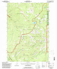
~ Wahtum Lake OR topo map, 1:24000 scale, 7.5 X 7.5 Minute, Historical, 1994, updated 1997
Wahtum Lake, Oregon, USGS topographic map dated 1994.
Includes geographic coordinates (latitude and longitude). This topographic map is suitable for hiking, camping, and exploring, or framing it as a wall map.
Printed on-demand using high resolution imagery, on heavy weight and acid free paper, or alternatively on a variety of synthetic materials.
Topos available on paper, Waterproof, Poly, or Tyvek. Usually shipping rolled, unless combined with other folded maps in one order.
- Product Number: USGS-5422600
- Free digital map download (high-resolution, GeoPDF): Wahtum Lake, Oregon (file size: 14 MB)
- Map Size: please refer to the dimensions of the GeoPDF map above
- Weight (paper map): ca. 55 grams
- Map Type: POD USGS Topographic Map
- Map Series: HTMC
- Map Verison: Historical
- Cell ID: 47172
- Scan ID: 281981
- Imprint Year: 1997
- Woodland Tint: Yes
- Aerial Photo Year: 1989
- Field Check Year: 1994
- Survey Year: 1973
- Datum: NAD27
- Map Projection: Lambert Conformal Conic
- Map published by United States Geological Survey
- Map published by United States Forest Service
- Map Language: English
- Scanner Resolution: 600 dpi
- Map Cell Name: Wahtum Lake
- Grid size: 7.5 X 7.5 Minute
- Date on map: 1994
- Map Scale: 1:24000
- Geographical region: Oregon, United States
Neighboring Maps:
All neighboring USGS topo maps are available for sale online at a variety of scales.
Spatial coverage:
Topo map Wahtum Lake, Oregon, covers the geographical area associated the following places:
- Opal Creek - Hicks Lake - Tunnel Falls - Green Point Mountain - Tomlike Mountain - Blue Grouse Campsite (historical) - Marco Creek - East Fork Eagle Creek - Seven-and-a-Half Mile Campsite (historical) - Indian Springs - Indian Springs Campground (historical) - Smokey Spring - Tumbledown Creek - Black Lake - Chinidere Mountain - Mud Lake - No Name Creek - Wy'East Campsite (historical) - Ottertail Lake - Washout Creek - Cedar Swamp Campsite (historical) - Skipper Creek - Midget Creek - Seven-and-a-Half Mile Campsite (historical) - Waucoma Ridge - Wahtum Lake Guard Station - Scout Lake - Wahtum Lake - Raker Point - Wahtum Lake Recreation Site - Simmons Creek - Indian Mountain - Mark O Hatfield Wilderness - Indianhead Rock - Eagle Creek Trail - Buck Point Creek - Sawtooth Mountain - Indian Creek - Sunshine Rock
- Map Area ID: AREA45.62545.5-121.875-121.75
- Northwest corner Lat/Long code: USGSNW45.625-121.875
- Northeast corner Lat/Long code: USGSNE45.625-121.75
- Southwest corner Lat/Long code: USGSSW45.5-121.875
- Southeast corner Lat/Long code: USGSSE45.5-121.75
- Northern map edge Latitude: 45.625
- Southern map edge Latitude: 45.5
- Western map edge Longitude: -121.875
- Eastern map edge Longitude: -121.75


