
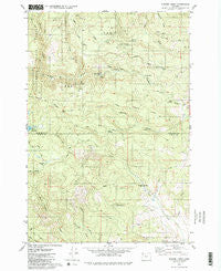
~ Turner Creek OR topo map, 1:24000 scale, 7.5 X 7.5 Minute, Historical, 1979, updated 1980
Turner Creek, Oregon, USGS topographic map dated 1979.
Includes geographic coordinates (latitude and longitude). This topographic map is suitable for hiking, camping, and exploring, or framing it as a wall map.
Printed on-demand using high resolution imagery, on heavy weight and acid free paper, or alternatively on a variety of synthetic materials.
Topos available on paper, Waterproof, Poly, or Tyvek. Usually shipping rolled, unless combined with other folded maps in one order.
- Product Number: USGS-5422440
- Free digital map download (high-resolution, GeoPDF): Turner Creek, Oregon (file size: 14 MB)
- Map Size: please refer to the dimensions of the GeoPDF map above
- Weight (paper map): ca. 55 grams
- Map Type: POD USGS Topographic Map
- Map Series: HTMC
- Map Verison: Historical
- Cell ID: 45979
- Scan ID: 281902
- Imprint Year: 1980
- Woodland Tint: Yes
- Aerial Photo Year: 1973
- Edit Year: 1979
- Field Check Year: 1974
- Datum: NAD27
- Map Projection: Lambert Conformal Conic
- Map published by United States Geological Survey
- Map Language: English
- Scanner Resolution: 600 dpi
- Map Cell Name: Turner Creek
- Grid size: 7.5 X 7.5 Minute
- Date on map: 1979
- Map Scale: 1:24000
- Geographical region: Oregon, United States
Neighboring Maps:
All neighboring USGS topo maps are available for sale online at a variety of scales.
Spatial coverage:
Topo map Turner Creek, Oregon, covers the geographical area associated the following places:
- Lee Creek - Neverstill - Four Corners - Yamhill Water Treatment Plant - Mathieu Creek - Homestead Ridge - Menefee County Park - Sunday Creek - Hagerty Ridge - Turner Creek Reservoir - Turner Creek Dam - Yamhill Reservoir - Hay Creek - Hawn Creek - Patten Creek - Severt Creek - East Fork Sain Creek - Lee Falls - Roaring Creek - Blind Cabin Ridge - Joint Water Commission Cherry Grove Slow Sand Filter Plant - Haines Falls - Wildwood Creek - Tuttle Point - Hillsboro Reservoir - Pike - Little Lee Falls
- Map Area ID: AREA45.545.375-123.375-123.25
- Northwest corner Lat/Long code: USGSNW45.5-123.375
- Northeast corner Lat/Long code: USGSNE45.5-123.25
- Southwest corner Lat/Long code: USGSSW45.375-123.375
- Southeast corner Lat/Long code: USGSSE45.375-123.25
- Northern map edge Latitude: 45.5
- Southern map edge Latitude: 45.375
- Western map edge Longitude: -123.375
- Eastern map edge Longitude: -123.25


