
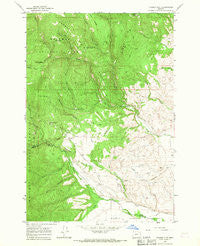
~ Tucker Flat OR topo map, 1:24000 scale, 7.5 X 7.5 Minute, Historical, 1965, updated 1967
Tucker Flat, Oregon, USGS topographic map dated 1965.
Includes geographic coordinates (latitude and longitude). This topographic map is suitable for hiking, camping, and exploring, or framing it as a wall map.
Printed on-demand using high resolution imagery, on heavy weight and acid free paper, or alternatively on a variety of synthetic materials.
Topos available on paper, Waterproof, Poly, or Tyvek. Usually shipping rolled, unless combined with other folded maps in one order.
- Product Number: USGS-5422404
- Free digital map download (high-resolution, GeoPDF): Tucker Flat, Oregon (file size: 14 MB)
- Map Size: please refer to the dimensions of the GeoPDF map above
- Weight (paper map): ca. 55 grams
- Map Type: POD USGS Topographic Map
- Map Series: HTMC
- Map Verison: Historical
- Cell ID: 45835
- Scan ID: 281884
- Imprint Year: 1967
- Woodland Tint: Yes
- Aerial Photo Year: 1960
- Field Check Year: 1965
- Datum: NAD27
- Map Projection: Polyconic
- Map published by United States Geological Survey
- Map Language: English
- Scanner Resolution: 600 dpi
- Map Cell Name: Tucker Flat
- Grid size: 7.5 X 7.5 Minute
- Date on map: 1965
- Map Scale: 1:24000
- Geographical region: Oregon, United States
Neighboring Maps:
All neighboring USGS topo maps are available for sale online at a variety of scales.
Spatial coverage:
Topo map Tucker Flat, Oregon, covers the geographical area associated the following places:
- Hunter Camp - Baker Creek - King Spring - Pilcher Creek Reservoir Recreation Site - Red Ridge - Shingle Gulch - Summit Spring - Lone Pine Ditch - Daley Creek - Wolf Creek Dam - Pilcher Creek Reservoir Dam - Goff Spring - Third Creek - Dark Canyon - Roger Creek - Summit Spring Ridge - Anthony Creek - Pilcher Creek Reservoir - Clear Creek - Shaw Mountain - North Fork Wolf Creek - Pilcher Creek Recreation Area - Pilcher Creek Reservoir Boat Ramp - West Fork Clear Creek - Tucker Flat - Wolf Creek Reservoir Boat Ramp - Elkhorn Wildlife Area - Wolf Creek Reservoir Recreation Site - Pilcher Creek - Anthony Gorge - Carnes Ditch - Bowman Spring - Metzler Creek - China Diggings - Wolf Creek Reservoir - Coughanour Ditch - Henrys Reservoir - Huddleston Reservoir - Dutch Creek - East Fork Clear Creek
- Map Area ID: AREA45.12545-118.125-118
- Northwest corner Lat/Long code: USGSNW45.125-118.125
- Northeast corner Lat/Long code: USGSNE45.125-118
- Southwest corner Lat/Long code: USGSSW45-118.125
- Southeast corner Lat/Long code: USGSSE45-118
- Northern map edge Latitude: 45.125
- Southern map edge Latitude: 45
- Western map edge Longitude: -118.125
- Eastern map edge Longitude: -118


