
~ Soldier Camp Mtn OR topo map, 1:24000 scale, 7.5 X 7.5 Minute, Historical, 1989, updated 1989
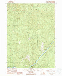
Soldier Camp Mtn, Oregon, USGS topographic map dated 1989.
Includes geographic coordinates (latitude and longitude). This topographic map is suitable for hiking, camping, and exploring, or framing it as a wall map.
Printed on-demand using high resolution imagery, on heavy weight and acid free paper, or alternatively on a variety of synthetic materials.
Topos available on paper, Waterproof, Poly, or Tyvek. Usually shipping rolled, unless combined with other folded maps in one order.
- Product Number: USGS-5421772
- Free digital map download (high-resolution, GeoPDF): Soldier Camp Mtn, Oregon (file size: 17 MB)
- Map Size: please refer to the dimensions of the GeoPDF map above
- Weight (paper map): ca. 55 grams
- Map Type: POD USGS Topographic Map
- Map Series: HTMC
- Map Verison: Historical
- Cell ID: 42000
- Scan ID: 281561
- Imprint Year: 1989
- Woodland Tint: Yes
- Aerial Photo Year: 1984
- Edit Year: 1989
- Field Check Year: 1986
- Datum: NAD27
- Map Projection: Lambert Conformal Conic
- Provisional map: Yes
- Map published by United States Geological Survey
- Map Language: English
- Scanner Resolution: 600 dpi
- Map Cell Name: Soldier Camp Mountain
- Grid size: 7.5 X 7.5 Minute
- Date on map: 1989
- Map Scale: 1:24000
- Geographical region: Oregon, United States
Neighboring Maps:
All neighboring USGS topo maps are available for sale online at a variety of scales.
Spatial coverage:
Topo map Soldier Camp Mtn, Oregon, covers the geographical area associated the following places:
- Bridge Creek - Silver Creek - New Riffle - Upper Coal Riffle - Auberry Creek - Skookumhouse Prairie - Schoolhouse Creek - Shindler Riffle - JoAnn Creek - Slide Creek - Rachels Delight Riffle - Lake of the Woods Mountain - Slide Creek Riffle - Fall Mountain - Sawtooth Rock - Wake Up Rilea Creek - Silver Creek Riffle - Bear Canyon - Little Canyon - Tom East Riffle - Combs Riffle - Bacon Flat - Bear Riffle - Steffin Meadow - Tom East Creek - Lower River Trail - Soldier Camp Mountain - Boulder Creek - South Fork Lobster Creek - Dog Creek - Iron Creek - Second Prairie Mountain - North Fork Lobster Creek - Adams Prairie - Nail Keg Creek - Auberry Riffle - Potato Illahe Mountain - Sherman Riffle - Nail Keg Riffle
- Map Area ID: AREA42.62542.5-124.25-124.125
- Northwest corner Lat/Long code: USGSNW42.625-124.25
- Northeast corner Lat/Long code: USGSNE42.625-124.125
- Southwest corner Lat/Long code: USGSSW42.5-124.25
- Southeast corner Lat/Long code: USGSSE42.5-124.125
- Northern map edge Latitude: 42.625
- Southern map edge Latitude: 42.5
- Western map edge Longitude: -124.25
- Eastern map edge Longitude: -124.125


