
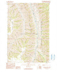
~ Sheep Creek Divide OR topo map, 1:24000 scale, 7.5 X 7.5 Minute, Historical, 1990, updated 1990
Sheep Creek Divide, Oregon, USGS topographic map dated 1990.
Includes geographic coordinates (latitude and longitude). This topographic map is suitable for hiking, camping, and exploring, or framing it as a wall map.
Printed on-demand using high resolution imagery, on heavy weight and acid free paper, or alternatively on a variety of synthetic materials.
Topos available on paper, Waterproof, Poly, or Tyvek. Usually shipping rolled, unless combined with other folded maps in one order.
- Product Number: USGS-5421572
- Free digital map download (high-resolution, GeoPDF): Sheep Creek Divide, Oregon (file size: 19 MB)
- Map Size: please refer to the dimensions of the GeoPDF map above
- Weight (paper map): ca. 55 grams
- Map Type: POD USGS Topographic Map
- Map Series: HTMC
- Map Verison: Historical
- Cell ID: 40871
- Scan ID: 281462
- Imprint Year: 1990
- Woodland Tint: Yes
- Aerial Photo Year: 1981
- Edit Year: 1990
- Field Check Year: 1987
- Datum: NAD27
- Map Projection: Lambert Conformal Conic
- Provisional map: Yes
- Map published by United States Geological Survey
- Map Language: English
- Scanner Resolution: 600 dpi
- Map Cell Name: Sheep Creek Divide
- Grid size: 7.5 X 7.5 Minute
- Date on map: 1990
- Map Scale: 1:24000
- Geographical region: Oregon, United States
Neighboring Maps:
All neighboring USGS topo maps are available for sale online at a variety of scales.
Spatial coverage:
Topo map Sheep Creek Divide, Oregon, covers the geographical area associated the following places:
- Loyd Creek - Godias Creek - Boneyard Creek - Sheep Creek Divide - Freezeout School (historical) - Campbell Creek - Indian Creek - Muley Creek - Cold Canyon - Beeler Ridge - Blackmore Creek - Cowhead Creek - Adams Creek - Wild Horse Creek - Gowing Spring - Turner Creek - Brown Creek - Granny Creek - Cripple Creek - Warden Creek - Gowing Creek - College Creek - Chalk Creek - Freezeout Trailhead - Dunlap Creek - Little Bristo Creek - Freezeout Creek - Dead Horse Ridge - Jody Creek - Bristo Creek - Snell Creek - East Muley Creek - Double Creek - Keeler Creek - Hope Creek - Happy Creek - Thorn Creek - Dunn Creek - Gaily Creek - Wilde Ranch - Schleur Creek - Steer Creek - College Creek Ranger Station (historical) - Lost Basin Creek - Spring Creek
- Map Area ID: AREA45.545.375-116.875-116.75
- Northwest corner Lat/Long code: USGSNW45.5-116.875
- Northeast corner Lat/Long code: USGSNE45.5-116.75
- Southwest corner Lat/Long code: USGSSW45.375-116.875
- Southeast corner Lat/Long code: USGSSE45.375-116.75
- Northern map edge Latitude: 45.5
- Southern map edge Latitude: 45.375
- Western map edge Longitude: -116.875
- Eastern map edge Longitude: -116.75


