
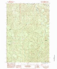
~ Roman Nose Mtn OR topo map, 1:24000 scale, 7.5 X 7.5 Minute, Historical, 1984, updated 1984
Roman Nose Mtn, Oregon, USGS topographic map dated 1984.
Includes geographic coordinates (latitude and longitude). This topographic map is suitable for hiking, camping, and exploring, or framing it as a wall map.
Printed on-demand using high resolution imagery, on heavy weight and acid free paper, or alternatively on a variety of synthetic materials.
Topos available on paper, Waterproof, Poly, or Tyvek. Usually shipping rolled, unless combined with other folded maps in one order.
- Product Number: USGS-5421270
- Free digital map download (high-resolution, GeoPDF): Roman Nose Mtn, Oregon (file size: 16 MB)
- Map Size: please refer to the dimensions of the GeoPDF map above
- Weight (paper map): ca. 55 grams
- Map Type: POD USGS Topographic Map
- Map Series: HTMC
- Map Verison: Historical
- Cell ID: 38484
- Scan ID: 281307
- Imprint Year: 1984
- Woodland Tint: Yes
- Aerial Photo Year: 1976
- Edit Year: 1984
- Field Check Year: 1979
- Datum: NAD27
- Map Projection: Universal Transverse Mercator
- Provisional map: Yes
- Map published by United States Geological Survey
- Map Language: English
- Scanner Resolution: 600 dpi
- Map Cell Name: Roman Nose Mountain
- Grid size: 7.5 X 7.5 Minute
- Date on map: 1984
- Map Scale: 1:24000
- Geographical region: Oregon, United States
Neighboring Maps:
All neighboring USGS topo maps are available for sale online at a variety of scales.
Spatial coverage:
Topo map Roman Nose Mtn, Oregon, covers the geographical area associated the following places:
- Cedar Creek - Esmond Creek - Whittaker Creek - Alma School (historical) - Ford Access Boat Ramp - Kline Creek - Twin Sisters Creek Camp (historical) - Linslaw Park Boat Ramp - Whittaker Creek Recreational Reservoir - Whittaker Creek Recreation Site - Bounds Creek - Roman Nose Mountain - Cox Creek - Leopold Creek - Sutherland Creek - Cabin Creek - Whittaker Creek Timber Pole Slide - Big Canyon Creek - Luce Place (historical) - Esmond Creek Recreation Area
- Map Area ID: AREA4443.875-123.75-123.625
- Northwest corner Lat/Long code: USGSNW44-123.75
- Northeast corner Lat/Long code: USGSNE44-123.625
- Southwest corner Lat/Long code: USGSSW43.875-123.75
- Southeast corner Lat/Long code: USGSSE43.875-123.625
- Northern map edge Latitude: 44
- Southern map edge Latitude: 43.875
- Western map edge Longitude: -123.75
- Eastern map edge Longitude: -123.625


