
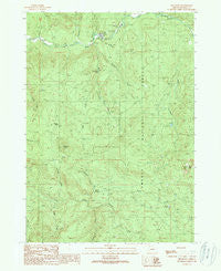
~ Red Butte OR topo map, 1:24000 scale, 7.5 X 7.5 Minute, Historical, 1989, updated 1990
Red Butte, Oregon, USGS topographic map dated 1989.
Includes geographic coordinates (latitude and longitude). This topographic map is suitable for hiking, camping, and exploring, or framing it as a wall map.
Printed on-demand using high resolution imagery, on heavy weight and acid free paper, or alternatively on a variety of synthetic materials.
Topos available on paper, Waterproof, Poly, or Tyvek. Usually shipping rolled, unless combined with other folded maps in one order.
- Product Number: USGS-5421136
- Free digital map download (high-resolution, GeoPDF): Red Butte, Oregon (file size: 16 MB)
- Map Size: please refer to the dimensions of the GeoPDF map above
- Weight (paper map): ca. 55 grams
- Map Type: POD USGS Topographic Map
- Map Series: HTMC
- Map Verison: Historical
- Cell ID: 37294
- Scan ID: 281238
- Imprint Year: 1990
- Woodland Tint: Yes
- Aerial Photo Year: 1983
- Edit Year: 1989
- Field Check Year: 1985
- Datum: NAD27
- Map Projection: Lambert Conformal Conic
- Provisional map: Yes
- Map published by United States Geological Survey
- Map Language: English
- Scanner Resolution: 600 dpi
- Map Cell Name: Red Butte
- Grid size: 7.5 X 7.5 Minute
- Date on map: 1989
- Map Scale: 1:24000
- Geographical region: Oregon, United States
Neighboring Maps:
All neighboring USGS topo maps are available for sale online at a variety of scales.
Spatial coverage:
Topo map Red Butte, Oregon, covers the geographical area associated the following places:
- Boundary Creek - Watson Cabin - Shivigny Creek - Liveoak Creek - Cultus Creek - West Fork Wolf Creek - Red Butte - Tuttle Creek - Egglestron Creek - Shadow Falls Campground - Wolf Creek Falls - Shadow Falls - Cavitt Lake - Tanners Pass - Red Butte Burn Camp - Emile Creek - Negro Creek - Wolf Creek Recreation Site - Plusfour Creek - Little Creek - Greenman Creek - Wolf Creek Job Corps Center - Sampson Butte - Sugar Pine Flat - Emile Creek Recreation Site - Wolf Creek Falls Recreation Site - Little River Christian Camp - Wolf Creek - Withrow Creek - Red Butte Lookout Tower - Negro Ridge
- Map Area ID: AREA43.2543.125-123-122.875
- Northwest corner Lat/Long code: USGSNW43.25-123
- Northeast corner Lat/Long code: USGSNE43.25-122.875
- Southwest corner Lat/Long code: USGSSW43.125-123
- Southeast corner Lat/Long code: USGSSE43.125-122.875
- Northern map edge Latitude: 43.25
- Southern map edge Latitude: 43.125
- Western map edge Longitude: -123
- Eastern map edge Longitude: -122.875


