
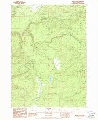
~ Prospect South OR topo map, 1:24000 scale, 7.5 X 7.5 Minute, Historical, 1988, updated 1988
Prospect South, Oregon, USGS topographic map dated 1988.
Includes geographic coordinates (latitude and longitude). This topographic map is suitable for hiking, camping, and exploring, or framing it as a wall map.
Printed on-demand using high resolution imagery, on heavy weight and acid free paper, or alternatively on a variety of synthetic materials.
Topos available on paper, Waterproof, Poly, or Tyvek. Usually shipping rolled, unless combined with other folded maps in one order.
- Product Number: USGS-5421026
- Free digital map download (high-resolution, GeoPDF): Prospect South, Oregon (file size: 13 MB)
- Map Size: please refer to the dimensions of the GeoPDF map above
- Weight (paper map): ca. 55 grams
- Map Type: POD USGS Topographic Map
- Map Series: HTMC
- Map Verison: Historical
- Cell ID: 36536
- Scan ID: 281182
- Imprint Year: 1988
- Woodland Tint: Yes
- Aerial Photo Year: 1983
- Edit Year: 1988
- Field Check Year: 1984
- Datum: NAD27
- Map Projection: Lambert Conformal Conic
- Provisional map: Yes
- Map published by United States Geological Survey
- Map Language: English
- Scanner Resolution: 600 dpi
- Map Cell Name: Prospect South
- Grid size: 7.5 X 7.5 Minute
- Date on map: 1988
- Map Scale: 1:24000
- Geographical region: Oregon, United States
Neighboring Maps:
All neighboring USGS topo maps are available for sale online at a variety of scales.
Spatial coverage:
Topo map Prospect South, Oregon, covers the geographical area associated the following places:
- Imnaha Creek - Vine Maple Creek - Cur Creek - Prospect State Airport - Middle Fork Rogue River - Conley Spring - Blue Goose Spring - Round Mountain Creek - Dailey Dam - Copco Powerhouse - Butte Falls-Prospect Division - Aiken County Park - Boundary Butte - Crane Creek - Mill-Mar Ranch - Barr Creek Falls - Red Blanket Creek - Geppert Creek - South Fork Parsnip Creek - Daniel Spring - Svinth Creek - Beaver Dam Creek - Twentynine Creek - Bessie Creek - Daniel Creek - Mill Creek - Parsnip Creek - Medco Pond - Elk Glade - Barr Creek - Zimmerman Burn - Middle Fork Parsnip Creek - Mill Creek Falls - Reinecke Burn - Oakridge School (historical) - Lodgepole Guard Station - Carney Flat - Gyppo Creek - South Fork Dam - Ash Creek - Cod Creek - Dead Dog Gulch - Prospect State Park - Buck Creek - South Fork Vine Maple Creek - Prospect Powerhouse
- Map Area ID: AREA42.7542.625-122.5-122.375
- Northwest corner Lat/Long code: USGSNW42.75-122.5
- Northeast corner Lat/Long code: USGSNE42.75-122.375
- Southwest corner Lat/Long code: USGSSW42.625-122.5
- Southeast corner Lat/Long code: USGSSE42.625-122.375
- Northern map edge Latitude: 42.75
- Southern map edge Latitude: 42.625
- Western map edge Longitude: -122.5
- Eastern map edge Longitude: -122.375


