
~ Potter Mtn OR topo map, 1:24000 scale, 7.5 X 7.5 Minute, Historical, 1986, updated 1986
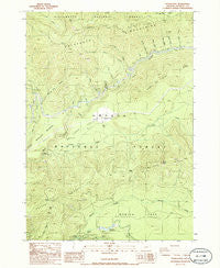
Potter Mtn, Oregon, USGS topographic map dated 1986.
Includes geographic coordinates (latitude and longitude). This topographic map is suitable for hiking, camping, and exploring, or framing it as a wall map.
Printed on-demand using high resolution imagery, on heavy weight and acid free paper, or alternatively on a variety of synthetic materials.
Topos available on paper, Waterproof, Poly, or Tyvek. Usually shipping rolled, unless combined with other folded maps in one order.
- Product Number: USGS-5420964
- Free digital map download (high-resolution, GeoPDF): Potter Mtn, Oregon (file size: 14 MB)
- Map Size: please refer to the dimensions of the GeoPDF map above
- Weight (paper map): ca. 55 grams
- Map Type: POD USGS Topographic Map
- Map Series: HTMC
- Map Verison: Historical
- Cell ID: 36205
- Scan ID: 281151
- Imprint Year: 1986
- Woodland Tint: Yes
- Aerial Photo Year: 1982
- Edit Year: 1986
- Field Check Year: 1983
- Datum: NAD27
- Map Projection: Lambert Conformal Conic
- Provisional map: Yes
- Map published by United States Geological Survey
- Map Language: English
- Scanner Resolution: 600 dpi
- Map Cell Name: Potter Mountain
- Grid size: 7.5 X 7.5 Minute
- Date on map: 1986
- Map Scale: 1:24000
- Geographical region: Oregon, United States
Neighboring Maps:
All neighboring USGS topo maps are available for sale online at a variety of scales.
Spatial coverage:
Topo map Potter Mtn, Oregon, covers the geographical area associated the following places:
- Patricia Creek - Clearwater Powerplant Number 1 - Dread and Terror Ridge - Watson Butte - Thorn Prairie - Watson Saddle - Clearwater Number Two Forebay Dam - Nurse Creek - Potter Creek - Winter Knight Camp - Potter Mountain - Sally Creek - Clearwater Number One Forebay - Deer Creek Diversion Dam - Barkenberger Creek - Upper Mountain Meadows - Pig Iron Mountain - Pig Iron Trail - Dorothy Creek - Calapooya Trail - Norma Creek - Nancy Creek - Karen Creek - Charlie Creek - Umpqua Hot Springs - Clearwater Number One Forebay Dam - Beverly Creek - Potter Mountain Trail - Lemolo Number 2 Canal - Watson Ridge - Helen Creek - Mowich Park - Laura Creek - Loafer Creek - Mowich Creek - Alvin Creek
- Map Area ID: AREA43.37543.25-122.375-122.25
- Northwest corner Lat/Long code: USGSNW43.375-122.375
- Northeast corner Lat/Long code: USGSNE43.375-122.25
- Southwest corner Lat/Long code: USGSSW43.25-122.375
- Southeast corner Lat/Long code: USGSSE43.25-122.25
- Northern map edge Latitude: 43.375
- Southern map edge Latitude: 43.25
- Western map edge Longitude: -122.375
- Eastern map edge Longitude: -122.25


