
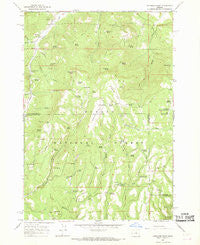
~ Peterson Point OR topo map, 1:24000 scale, 7.5 X 7.5 Minute, Historical, 1966, updated 1968
Peterson Point, Oregon, USGS topographic map dated 1966.
Includes geographic coordinates (latitude and longitude). This topographic map is suitable for hiking, camping, and exploring, or framing it as a wall map.
Printed on-demand using high resolution imagery, on heavy weight and acid free paper, or alternatively on a variety of synthetic materials.
Topos available on paper, Waterproof, Poly, or Tyvek. Usually shipping rolled, unless combined with other folded maps in one order.
- Product Number: USGS-5420826
- Free digital map download (high-resolution, GeoPDF): Peterson Point, Oregon (file size: 12 MB)
- Map Size: please refer to the dimensions of the GeoPDF map above
- Weight (paper map): ca. 55 grams
- Map Type: POD USGS Topographic Map
- Map Series: HTMC
- Map Verison: Historical
- Cell ID: 34885
- Scan ID: 281076
- Imprint Year: 1968
- Woodland Tint: Yes
- Aerial Photo Year: 1959
- Field Check Year: 1966
- Datum: NAD27
- Map Projection: Polyconic
- Map published by United States Geological Survey
- Map Language: English
- Scanner Resolution: 600 dpi
- Map Cell Name: Peterson Point
- Grid size: 7.5 X 7.5 Minute
- Date on map: 1966
- Map Scale: 1:24000
- Geographical region: Oregon, United States
Neighboring Maps:
All neighboring USGS topo maps are available for sale online at a variety of scales.
Spatial coverage:
Topo map Peterson Point, Oregon, covers the geographical area associated the following places:
- Packsaddle Spring - Big Happy Spring - Black Mountain - Go Spring - Lonesome Spring - Milk Creek - Goofy Spring - Looney Reservoir - Blackjoe Spring - Dry Porter Creek - Peterson Point - Packsaddle Reservoir - Happy Camp Spring - Hegel Spring - Tom Spring - Woodin Spring - Ernie Spring - Twin Trough Spring - Lonesome Spring Campground - Rainier Spring - Division Spring - Mud Spring - Seeley Spring - Kitty Creek - Fox Spring - East Fork Crazy Creek - Lost Spring - Little Happy Spring - Black Mountain Lookout (historical) - Lava Spring - Peterson Lava - Fritts Spring - Porter Spring - Alder Spring - East Porter Creek - Monroe Spring - West Fork Crazy Creek - Peterson Spring - McCarthy Spring - Varmint Creek - Port Spring - Broadway Lava - Antelope Spring - Cram Spring - Happy Spring - Woodchuck Spring - Jones Troughs - Crazy Spring - Foss Spring - Dowell Spring - Jones Lava - Hoffman Creek - Fir Tree Spring - Peter Spring - Broadway Spring - Dick Nickolas Spring - Zane Spring
- Map Area ID: AREA44.544.375-120.125-120
- Northwest corner Lat/Long code: USGSNW44.5-120.125
- Northeast corner Lat/Long code: USGSNE44.5-120
- Southwest corner Lat/Long code: USGSSW44.375-120.125
- Southeast corner Lat/Long code: USGSSE44.375-120
- Northern map edge Latitude: 44.5
- Southern map edge Latitude: 44.375
- Western map edge Longitude: -120.125
- Eastern map edge Longitude: -120


