
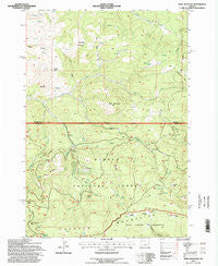
~ Opal Mountain OR topo map, 1:24000 scale, 7.5 X 7.5 Minute, Historical, 1992, updated 1998
Opal Mountain, Oregon, USGS topographic map dated 1992.
Includes geographic coordinates (latitude and longitude). This topographic map is suitable for hiking, camping, and exploring, or framing it as a wall map.
Printed on-demand using high resolution imagery, on heavy weight and acid free paper, or alternatively on a variety of synthetic materials.
Topos available on paper, Waterproof, Poly, or Tyvek. Usually shipping rolled, unless combined with other folded maps in one order.
- Product Number: USGS-5420660
- Free digital map download (high-resolution, GeoPDF): Opal Mountain, Oregon (file size: 14 MB)
- Map Size: please refer to the dimensions of the GeoPDF map above
- Weight (paper map): ca. 55 grams
- Map Type: POD USGS Topographic Map
- Map Series: HTMC
- Map Verison: Historical
- Cell ID: 33299
- Scan ID: 280989
- Imprint Year: 1998
- Woodland Tint: Yes
- Aerial Photo Year: 1991
- Field Check Year: 1992
- Datum: NAD27
- Map Projection: Lambert Conformal Conic
- Map published by United States Geological Survey
- Map published by United States Forest Service
- Map Language: English
- Scanner Resolution: 600 dpi
- Map Cell Name: Opal Mountain
- Grid size: 7.5 X 7.5 Minute
- Date on map: 1992
- Map Scale: 1:24000
- Geographical region: Oregon, United States
Neighboring Maps:
All neighboring USGS topo maps are available for sale online at a variety of scales.
Spatial coverage:
Topo map Opal Mountain, Oregon, covers the geographical area associated the following places:
- Skookum Rock - Symons Wood Camp - Trail Cabin - Three C Spring - Divide Cabin - Jones Gulch - Potlid Creek - Cougar Rock - Skull Spring - Rooster Rock Spring - Bingham Spring - Bingham Prairie - Stove Spring - Opal Creek - West Fork Trout Creek - Trail Meadow - Moccasin Prairie - Dick Creek - Auger Creek - Doe Spring - Bingham Prairie Campground - Dick Bluff - Ingram Spring - Box Spring - Carwin Spring - Roundup Grounds - Keller Cabin Spring - Cougar Spring - Lodgepole Spring - Opal Mountain - Divide Spring - Iron Mountain - Whiskey Spring - Bull Mountain - Telfer Butte - Bull Creek - Ingram Point - Rooster Rock - Tamarack Spring
- Map Area ID: AREA44.62544.5-120.625-120.5
- Northwest corner Lat/Long code: USGSNW44.625-120.625
- Northeast corner Lat/Long code: USGSNE44.625-120.5
- Southwest corner Lat/Long code: USGSSW44.5-120.625
- Southeast corner Lat/Long code: USGSSE44.5-120.5
- Northern map edge Latitude: 44.625
- Southern map edge Latitude: 44.5
- Western map edge Longitude: -120.625
- Eastern map edge Longitude: -120.5


