
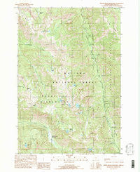
~ North Minam Meadows OR topo map, 1:24000 scale, 7.5 X 7.5 Minute, Historical, 1990, updated 1990
North Minam Meadows, Oregon, USGS topographic map dated 1990.
Includes geographic coordinates (latitude and longitude). This topographic map is suitable for hiking, camping, and exploring, or framing it as a wall map.
Printed on-demand using high resolution imagery, on heavy weight and acid free paper, or alternatively on a variety of synthetic materials.
Topos available on paper, Waterproof, Poly, or Tyvek. Usually shipping rolled, unless combined with other folded maps in one order.
- Product Number: USGS-5420556
- Free digital map download (high-resolution, GeoPDF): North Minam Meadows, Oregon (file size: 18 MB)
- Map Size: please refer to the dimensions of the GeoPDF map above
- Weight (paper map): ca. 55 grams
- Map Type: POD USGS Topographic Map
- Map Series: HTMC
- Map Verison: Historical
- Cell ID: 32403
- Scan ID: 280934
- Imprint Year: 1990
- Woodland Tint: Yes
- Aerial Photo Year: 1981
- Edit Year: 1990
- Field Check Year: 1987
- Datum: NAD27
- Map Projection: Lambert Conformal Conic
- Provisional map: Yes
- Map published by United States Geological Survey
- Map Language: English
- Scanner Resolution: 600 dpi
- Map Cell Name: North Minam Meadows
- Grid size: 7.5 X 7.5 Minute
- Date on map: 1990
- Map Scale: 1:24000
- Geographical region: Oregon, United States
Neighboring Maps:
All neighboring USGS topo maps are available for sale online at a variety of scales.
Spatial coverage:
Topo map North Minam Meadows, Oregon, covers the geographical area associated the following places:
- King Forest Camp - North Minam Guard Station - Wilson Basin - Lillyville Forest Camp - Lostine Guard Station - Sandy Saddle - Lillyville Trailhead - Bear Creek Trail - Bear Lake - Maxwell Lake - Arrow Recreation Site - Lapover Meadows - Green Lake - North Minam Trail - French Camp Recreation Site - Little Storm Lake - Storm Creek - Bowman Creek - Swamp Basin - Brownie Basin - French Creek - North Minam Meadows - Marble Point - McCubbin Basin - Miner Spring - Bowman Trail - Shady Recreation Site - Wood Lake - Lake Creek - Williamson Recreation Site - Chimney Lake - Two Pan Recreation Site - Lookout Mountain - Turkey Flat Recreation Site - Jackson Lake - Irondyke Recreation Site - Hunter Falls - Cold Spring - Lapover Lake - John Henry Lake - Goat Mountain - Middle Bear Camp - Sturgil Saddle - Flagstaff Point - Hobo Lake - Lake Creek Forest Camp - Lapover Ranch - Walla Walla Recreation Site - Laverty Lakes
- Map Area ID: AREA45.37545.25-117.5-117.375
- Northwest corner Lat/Long code: USGSNW45.375-117.5
- Northeast corner Lat/Long code: USGSNE45.375-117.375
- Southwest corner Lat/Long code: USGSSW45.25-117.5
- Southeast corner Lat/Long code: USGSSE45.25-117.375
- Northern map edge Latitude: 45.375
- Southern map edge Latitude: 45.25
- Western map edge Longitude: -117.5
- Eastern map edge Longitude: -117.375


