
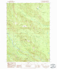
~ Mt David Douglas OR topo map, 1:24000 scale, 7.5 X 7.5 Minute, Historical, 1986, updated 1986
Mt David Douglas, Oregon, USGS topographic map dated 1986.
Includes geographic coordinates (latitude and longitude). This topographic map is suitable for hiking, camping, and exploring, or framing it as a wall map.
Printed on-demand using high resolution imagery, on heavy weight and acid free paper, or alternatively on a variety of synthetic materials.
Topos available on paper, Waterproof, Poly, or Tyvek. Usually shipping rolled, unless combined with other folded maps in one order.
- Product Number: USGS-5420398
- Free digital map download (high-resolution, GeoPDF): Mt David Douglas, Oregon (file size: 16 MB)
- Map Size: please refer to the dimensions of the GeoPDF map above
- Weight (paper map): ca. 55 grams
- Map Type: POD USGS Topographic Map
- Map Series: HTMC
- Map Verison: Historical
- Cell ID: 30554
- Scan ID: 280853
- Imprint Year: 1986
- Woodland Tint: Yes
- Aerial Photo Year: 1982
- Edit Year: 1986
- Field Check Year: 1983
- Datum: NAD27
- Map Projection: Lambert Conformal Conic
- Provisional map: Yes
- Map published by United States Geological Survey
- Map Language: English
- Scanner Resolution: 600 dpi
- Map Cell Name: Mount David Douglas
- Grid size: 7.5 X 7.5 Minute
- Date on map: 1986
- Map Scale: 1:24000
- Geographical region: Oregon, United States
Neighboring Maps:
All neighboring USGS topo maps are available for sale online at a variety of scales.
Spatial coverage:
Topo map Mt David Douglas, Oregon, covers the geographical area associated the following places:
- South Fork Salt Creek - Cedar Creek - Eagle Creek - Doe Creek - Louise Creek - Petite Creek - Cornpatch Prairie - Spirit Lake - Helen Creek Way - Mount David Douglas - Coyote Creek - Verdun Rock - Rhododendron Island - Twin Creek - Cruzatte Post Office (historical) - Lucas Lake - Heather - Cupit Mary Trail - Eagle Camp - Swamp Creek - Beamer Ranch - Koch Mountain Trail - Verdun Way - Last Creek - Big Bunchgrass - Salt Creek Safety Rest Area (historical) - Noisy Creek - Cascade Creek - Bunchgrass Ridge - Shady Creek - Fuji Meadow - Cruzatte - Hells Hall Acre
- Map Area ID: AREA43.7543.625-122.25-122.125
- Northwest corner Lat/Long code: USGSNW43.75-122.25
- Northeast corner Lat/Long code: USGSNE43.75-122.125
- Southwest corner Lat/Long code: USGSSW43.625-122.25
- Southeast corner Lat/Long code: USGSSE43.625-122.125
- Northern map edge Latitude: 43.75
- Southern map edge Latitude: 43.625
- Western map edge Longitude: -122.25
- Eastern map edge Longitude: -122.125


