
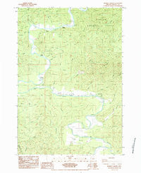
~ Mowrey Landing OR topo map, 1:24000 scale, 7.5 X 7.5 Minute, Historical, 1984, updated 1984
Mowrey Landing, Oregon, USGS topographic map dated 1984.
Includes geographic coordinates (latitude and longitude). This topographic map is suitable for hiking, camping, and exploring, or framing it as a wall map.
Printed on-demand using high resolution imagery, on heavy weight and acid free paper, or alternatively on a variety of synthetic materials.
Topos available on paper, Waterproof, Poly, or Tyvek. Usually shipping rolled, unless combined with other folded maps in one order.
- Product Number: USGS-5420388
- Free digital map download (high-resolution, GeoPDF): Mowrey Landing, Oregon (file size: 13 MB)
- Map Size: please refer to the dimensions of the GeoPDF map above
- Weight (paper map): ca. 55 grams
- Map Type: POD USGS Topographic Map
- Map Series: HTMC
- Map Verison: Historical
- Cell ID: 30985
- Scan ID: 280848
- Imprint Year: 1984
- Woodland Tint: Yes
- Aerial Photo Year: 1976
- Edit Year: 1984
- Field Check Year: 1979
- Datum: NAD27
- Map Projection: Lambert Conformal Conic
- Provisional map: Yes
- Map published by United States Geological Survey
- Map Language: English
- Scanner Resolution: 600 dpi
- Map Cell Name: Mowrey Landing
- Grid size: 7.5 X 7.5 Minute
- Date on map: 1984
- Map Scale: 1:24000
- Geographical region: Oregon, United States
Neighboring Maps:
All neighboring USGS topo maps are available for sale online at a variety of scales.
Spatial coverage:
Topo map Mowrey Landing, Oregon, covers the geographical area associated the following places:
- Chitwood Creek - Reed Creek - North Roy Creek - Wade Creek - Mowrey Landing - Davis Creek - Jack Morgan County Park - Stemple Creek - Martin Eddy Creek - Reed Creek - Stewart Creek - Townsend Creek - Butterfield Riffle - Camas Prairie - Bear Creek - Roots Post Office (historical) - The Maples - Roots Creek - Thompson Creek - Mack Landing - Foster Creek - Cedar Creek - Scare Creek - Jaybird Creek - Foster Creek - KCRF-FM - Dry Creek - Melco Landing - Butterfield Creek - Strome Park Boat Ramp - Misac Creek - Skalada Creek - Morgan Park Boat Ramp - Reed Creek Grange - Ojalla Creek - Strome County Park - South Roy Creek - Roy Creek - Morgan Landing - Hough Creek - Euchre Creek - Martin Eddy - Grave Creek - Depoe Bay Division - Ojalla Bridge
- Map Area ID: AREA44.87544.75-124-123.875
- Northwest corner Lat/Long code: USGSNW44.875-124
- Northeast corner Lat/Long code: USGSNE44.875-123.875
- Southwest corner Lat/Long code: USGSSW44.75-124
- Southeast corner Lat/Long code: USGSSE44.75-123.875
- Northern map edge Latitude: 44.875
- Southern map edge Latitude: 44.75
- Western map edge Longitude: -124
- Eastern map edge Longitude: -123.875


