
~ Mount Reuben OR topo map, 1:24000 scale, 7.5 X 7.5 Minute, Historical, 1989, updated 1989
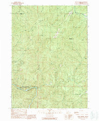
Mount Reuben, Oregon, USGS topographic map dated 1989.
Includes geographic coordinates (latitude and longitude). This topographic map is suitable for hiking, camping, and exploring, or framing it as a wall map.
Printed on-demand using high resolution imagery, on heavy weight and acid free paper, or alternatively on a variety of synthetic materials.
Topos available on paper, Waterproof, Poly, or Tyvek. Usually shipping rolled, unless combined with other folded maps in one order.
- Product Number: USGS-5420356
- Free digital map download (high-resolution, GeoPDF): Mount Reuben, Oregon (file size: 18 MB)
- Map Size: please refer to the dimensions of the GeoPDF map above
- Weight (paper map): ca. 55 grams
- Map Type: POD USGS Topographic Map
- Map Series: HTMC
- Map Verison: Historical
- Cell ID: 72471
- Scan ID: 280832
- Imprint Year: 1989
- Woodland Tint: Yes
- Aerial Photo Year: 1984
- Edit Year: 1989
- Field Check Year: 1986
- Datum: NAD27
- Map Projection: Lambert Conformal Conic
- Provisional map: Yes
- Map published by United States Geological Survey
- Map Language: English
- Scanner Resolution: 600 dpi
- Map Cell Name: Mount Reuben
- Grid size: 7.5 X 7.5 Minute
- Date on map: 1989
- Map Scale: 1:24000
- Geographical region: Oregon, United States
Neighboring Maps:
All neighboring USGS topo maps are available for sale online at a variety of scales.
Spatial coverage:
Topo map Mount Reuben, Oregon, covers the geographical area associated the following places:
- Molly Hill Mine - Butte Creek - Panther Creek - Tibbett Spring - Marion Creek - Dry Creek - Grave Creek Boat Ramp - Johnson Spring - Ajax Mine - Rock Creek - Hungry Hill - Gold Bug Gulch - Singletree Gulch - Rainie Falls - California Mine - Bear Spring - Gold Bug Mine - Grave Creek Riffle - McNair Creek - Reuben Creek - China Gulch - China Gulch Rapids - Fall Creek - Smith Gulch - Archer Mine - Baker Mine - J C L Mine - Reservoir Creek - Pine Cone Spring - Poorman Creek - Grave Creek Falls - Argo Boat Launch - Berglund Gulch - Harris Creek - McKnabe Creek - Windy Gap Mine - One Doe Spring - Bantam Mine - Perkins Prairie - Victory Mine - Sawmill Gap - Ajax Gulch - Grave Creek Bridge - Mount Reuben - Swanson Creek - Goff Mine - Grave Creek - Battle Creek - Pix Mine
- Map Area ID: AREA42.7542.625-123.625-123.5
- Northwest corner Lat/Long code: USGSNW42.75-123.625
- Northeast corner Lat/Long code: USGSNE42.75-123.5
- Southwest corner Lat/Long code: USGSSW42.625-123.625
- Southeast corner Lat/Long code: USGSSE42.625-123.5
- Northern map edge Latitude: 42.75
- Southern map edge Latitude: 42.625
- Western map edge Longitude: -123.625
- Eastern map edge Longitude: -123.5


