
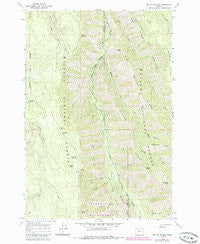
~ Mount Moriah OR topo map, 1:24000 scale, 7.5 X 7.5 Minute, Historical, 1965, updated 1985
Mount Moriah, Oregon, USGS topographic map dated 1965.
Includes geographic coordinates (latitude and longitude). This topographic map is suitable for hiking, camping, and exploring, or framing it as a wall map.
Printed on-demand using high resolution imagery, on heavy weight and acid free paper, or alternatively on a variety of synthetic materials.
Topos available on paper, Waterproof, Poly, or Tyvek. Usually shipping rolled, unless combined with other folded maps in one order.
- Product Number: USGS-5420346
- Free digital map download (high-resolution, GeoPDF): Mount Moriah, Oregon (file size: 16 MB)
- Map Size: please refer to the dimensions of the GeoPDF map above
- Weight (paper map): ca. 55 grams
- Map Type: POD USGS Topographic Map
- Map Series: HTMC
- Map Verison: Historical
- Cell ID: 30721
- Scan ID: 280827
- Imprint Year: 1985
- Woodland Tint: Yes
- Photo Revision Year: 1984
- Aerial Photo Year: 1981
- Edit Year: 1984
- Field Check Year: 1965
- Datum: NAD27
- Map Projection: Polyconic
- Map published by United States Geological Survey
- Map Language: English
- Scanner Resolution: 600 dpi
- Map Cell Name: Mount Moriah
- Grid size: 7.5 X 7.5 Minute
- Date on map: 1965
- Map Scale: 1:24000
- Geographical region: Oregon, United States
Neighboring Maps:
All neighboring USGS topo maps are available for sale online at a variety of scales.
Spatial coverage:
Topo map Mount Moriah, Oregon, covers the geographical area associated the following places:
- Horse Meadow - Mount Moriah - Cougar Ridge Trail - Eagle Creek - Faun Creek - Division Gulch - Burnt Spring - Crooked Trail - Lobo Creek - Elk Point - Little Minam River - Line Bluff - Grouse Creek - Jim Spring - Chicken Spring - Horse Basin Creek - Cougar Ridge - Bluch Creek - Big Sheep Ridge - Murphy Creek - Mahogany Ridge - Trippier Point - Coyote Spring - High Ridge - Twin Spring - Moonrise Spring - Collusion Point - Dunning Creek - Little Sheep Ridge - Rock Spring Trail - Rock Spring - Monument Point
- Map Area ID: AREA45.545.375-117.75-117.625
- Northwest corner Lat/Long code: USGSNW45.5-117.75
- Northeast corner Lat/Long code: USGSNE45.5-117.625
- Southwest corner Lat/Long code: USGSSW45.375-117.75
- Southeast corner Lat/Long code: USGSSE45.375-117.625
- Northern map edge Latitude: 45.5
- Southern map edge Latitude: 45.375
- Western map edge Longitude: -117.75
- Eastern map edge Longitude: -117.625


