
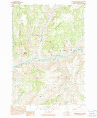
~ Masiker Mountain OR topo map, 1:24000 scale, 7.5 X 7.5 Minute, Historical, 1990, updated 1990
Masiker Mountain, Oregon, USGS topographic map dated 1990.
Includes geographic coordinates (latitude and longitude). This topographic map is suitable for hiking, camping, and exploring, or framing it as a wall map.
Printed on-demand using high resolution imagery, on heavy weight and acid free paper, or alternatively on a variety of synthetic materials.
Topos available on paper, Waterproof, Poly, or Tyvek. Usually shipping rolled, unless combined with other folded maps in one order.
- Product Number: USGS-5420006
- Free digital map download (high-resolution, GeoPDF): Masiker Mountain, Oregon (file size: 14 MB)
- Map Size: please refer to the dimensions of the GeoPDF map above
- Weight (paper map): ca. 55 grams
- Map Type: POD USGS Topographic Map
- Map Series: HTMC
- Map Verison: Historical
- Cell ID: 70829
- Scan ID: 280652
- Imprint Year: 1990
- Woodland Tint: Yes
- Aerial Photo Year: 1984
- Edit Year: 1990
- Field Check Year: 1987
- Datum: NAD27
- Map Projection: Lambert Conformal Conic
- Provisional map: Yes
- Map published by United States Geological Survey
- Map Language: English
- Scanner Resolution: 600 dpi
- Map Cell Name: Masiker Mountain
- Grid size: 7.5 X 7.5 Minute
- Date on map: 1990
- Map Scale: 1:24000
- Geographical region: Oregon, United States
Neighboring Maps:
All neighboring USGS topo maps are available for sale online at a variety of scales.
Spatial coverage:
Topo map Masiker Mountain, Oregon, covers the geographical area associated the following places:
- Grassy Dell Creek - Donnelly Basin - Wills Canyon - William Creek - Starvation Ridge - Hawk Ridge - Donnely Creek - Mathas Creek - Juniper Ridge - Alder Mountain - Hoogie Doogie Mountain - Masiker Mountain - Harper Creek - Rimrock Spring - Dippen Rig Creek - Ben Glenn Canyon - Mule Shoe Boat Launch - Horseshoe Creek - Masiker Canyon - Juniper Canyon - Sourdough Ridge - Rollin Canyon - Alder Creek - Rock Creek - Forked Canyon - Muleshoe Mountain - Solitude Canyon - Muleshoe Creek - Wooden Bridge Boat Launch - Lake Creek
- Map Area ID: AREA44.87544.75-120-119.875
- Northwest corner Lat/Long code: USGSNW44.875-120
- Northeast corner Lat/Long code: USGSNE44.875-119.875
- Southwest corner Lat/Long code: USGSSW44.75-120
- Southeast corner Lat/Long code: USGSSE44.75-119.875
- Northern map edge Latitude: 44.875
- Southern map edge Latitude: 44.75
- Western map edge Longitude: -120
- Eastern map edge Longitude: -119.875


