
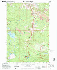
~ Marion Lake OR topo map, 1:24000 scale, 7.5 X 7.5 Minute, Historical, 1997, updated 2001
Marion Lake, Oregon, USGS topographic map dated 1997.
Includes geographic coordinates (latitude and longitude). This topographic map is suitable for hiking, camping, and exploring, or framing it as a wall map.
Printed on-demand using high resolution imagery, on heavy weight and acid free paper, or alternatively on a variety of synthetic materials.
Topos available on paper, Waterproof, Poly, or Tyvek. Usually shipping rolled, unless combined with other folded maps in one order.
- Product Number: USGS-5419994
- Free digital map download (high-resolution, GeoPDF): Marion Lake, Oregon (file size: 16 MB)
- Map Size: please refer to the dimensions of the GeoPDF map above
- Weight (paper map): ca. 55 grams
- Map Type: POD USGS Topographic Map
- Map Series: HTMC
- Map Verison: Historical
- Cell ID: 27731
- Scan ID: 280646
- Imprint Year: 2001
- Woodland Tint: Yes
- Aerial Photo Year: 1995
- Edit Year: 1997
- Survey Year: 1949
- Datum: NAD27
- Map Projection: Lambert Conformal Conic
- Map published by United States Geological Survey
- Map published by United States Forest Service
- Map Language: English
- Scanner Resolution: 600 dpi
- Map Cell Name: Marion Lake
- Grid size: 7.5 X 7.5 Minute
- Date on map: 1997
- Map Scale: 1:24000
- Geographical region: Oregon, United States
Neighboring Maps:
All neighboring USGS topo maps are available for sale online at a variety of scales.
Spatial coverage:
Topo map Marion Lake, Oregon, covers the geographical area associated the following places:
- Jenny Lake - Blue Lake Trail - Koko Lake - Eight Lakes Creek - Mount Jefferson Wilderness - John Swallow Grave - Little Bowerman Lake - Lake of the Woods - Swallow Lake - Swallow Lake Trail - Whiskey Lake - Lava Spring - Marion Lake Guard Station - Teto Lake - Minto Lake - Lake Ann - Sad Lake - Prill Lake - Jorn Lake - Melis Lake - Bowerman Lake - Camp Marion - Red Butte Lake - Forked Butte - Rockpile Lake - North Cinder Peak - Carl Lake - Marion Lake - Junction Lake - Bear Valley - Minto Pass Trail - Lizard Point - Patsy Lake - Whiskey Creek - Shirley Lake - Bingham Lake - Catlin Lake - Brush Creek Trail - Mazama Creek Campground (historical) - Bingham Basin - Jack Creek - Table Lake - Papoose Lake - Horse Pasture Creek - Mist Creek - Cabot Lake - Wasco Lake - Red Butte - Minto Pass - Rockpile Mountain - Bingham Ridge Trail - South Cinder Peak - Alice Lake - Chiquito Lake - Blue Lake - Cathedral Rocks - Eight Lakes Basin - Summit Trail - Lizard Ridge - Midget Lake - Bear Valley Lake - Jefferson Lake
- Map Area ID: AREA44.62544.5-121.875-121.75
- Northwest corner Lat/Long code: USGSNW44.625-121.875
- Northeast corner Lat/Long code: USGSNE44.625-121.75
- Southwest corner Lat/Long code: USGSSW44.5-121.875
- Southeast corner Lat/Long code: USGSSE44.5-121.75
- Northern map edge Latitude: 44.625
- Southern map edge Latitude: 44.5
- Western map edge Longitude: -121.875
- Eastern map edge Longitude: -121.75


