
~ Lee Thomas Crossing OR topo map, 1:24000 scale, 7.5 X 7.5 Minute, Historical, 2004, updated 2007
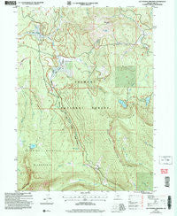
Lee Thomas Crossing, Oregon, USGS topographic map dated 2004.
Includes geographic coordinates (latitude and longitude). This topographic map is suitable for hiking, camping, and exploring, or framing it as a wall map.
Printed on-demand using high resolution imagery, on heavy weight and acid free paper, or alternatively on a variety of synthetic materials.
Topos available on paper, Waterproof, Poly, or Tyvek. Usually shipping rolled, unless combined with other folded maps in one order.
- Product Number: USGS-5419700
- Free digital map download (high-resolution, GeoPDF): Lee Thomas Crossing, Oregon (file size: 15 MB)
- Map Size: please refer to the dimensions of the GeoPDF map above
- Weight (paper map): ca. 55 grams
- Map Type: POD USGS Topographic Map
- Map Series: HTMC
- Map Verison: Historical
- Cell ID: 25304
- Scan ID: 280497
- Imprint Year: 2007
- Woodland Tint: Yes
- Aerial Photo Year: 2000
- Edit Year: 2004
- Datum: NAD83
- Map Projection: Universal Transverse Mercator
- Map published by United States Geological Survey
- Map published by United States Forest Service
- Map Language: English
- Scanner Resolution: 600 dpi
- Map Cell Name: Lee Thomas Crossing
- Grid size: 7.5 X 7.5 Minute
- Date on map: 2004
- Map Scale: 1:24000
- Geographical region: Oregon, United States
Neighboring Maps:
All neighboring USGS topo maps are available for sale online at a variety of scales.
Spatial coverage:
Topo map Lee Thomas Crossing, Oregon, covers the geographical area associated the following places:
- Campbell Lake - White Horse Creek - Mulky Meadow - Lee Thomas Meadow - Ingram Guard Station - Dead Cow Creek - Bald Butte Lookout - Dead Horse Lake Recreation Site - Blue Lake - School Creek - North Fork Sprague River Trailhead - Gearhart Mountain Wilderness - Bald Butte Spring - Deadhorse Lake Campground Boat Ramp - Campbell Lake Recreation Site - Cache Camp - North Creek - Nottin Creek - Pole Creek - Walker Creek - North Creek Campground - Dead Horse Rim - Head of River Spring - Dead Horse Lake - Gold Creek - Campbell Lake Boat Ramp - Lee Thomas Recreation Site - Lee Thomas Crossing - Dairy Creek Campground (historical) - Wagon Wheel Creek - Gearhart Marsh - Frigid Spring - Lakes Loop Trailhead - Hole Creek - Wagon Wheel Flat - Bald Butte
- Map Area ID: AREA42.62542.5-120.875-120.75
- Northwest corner Lat/Long code: USGSNW42.625-120.875
- Northeast corner Lat/Long code: USGSNE42.625-120.75
- Southwest corner Lat/Long code: USGSSW42.5-120.875
- Southeast corner Lat/Long code: USGSSE42.5-120.75
- Northern map edge Latitude: 42.625
- Southern map edge Latitude: 42.5
- Western map edge Longitude: -120.875
- Eastern map edge Longitude: -120.75


