
~ Lane Mountain OR topo map, 1:24000 scale, 7.5 X 7.5 Minute, Historical, 1998, updated 2000
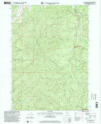
Lane Mountain, Oregon, USGS topographic map dated 1998.
Includes geographic coordinates (latitude and longitude). This topographic map is suitable for hiking, camping, and exploring, or framing it as a wall map.
Printed on-demand using high resolution imagery, on heavy weight and acid free paper, or alternatively on a variety of synthetic materials.
Topos available on paper, Waterproof, Poly, or Tyvek. Usually shipping rolled, unless combined with other folded maps in one order.
- Product Number: USGS-5419596
- Free digital map download (high-resolution, GeoPDF): Lane Mountain, Oregon (file size: 16 MB)
- Map Size: please refer to the dimensions of the GeoPDF map above
- Weight (paper map): ca. 55 grams
- Map Type: POD USGS Topographic Map
- Map Series: HTMC
- Map Verison: Historical
- Cell ID: 24890
- Scan ID: 280466
- Imprint Year: 2000
- Woodland Tint: Yes
- Aerial Photo Year: 1982
- Edit Year: 1998
- Datum: NAD27
- Map Projection: Lambert Conformal Conic
- Map published by United States Geological Survey
- Map published by United States Forest Service
- Map Language: English
- Scanner Resolution: 600 dpi
- Map Cell Name: Lane Mountain
- Grid size: 7.5 X 7.5 Minute
- Date on map: 1998
- Map Scale: 1:24000
- Geographical region: Oregon, United States
Neighboring Maps:
All neighboring USGS topo maps are available for sale online at a variety of scales.
Spatial coverage:
Topo map Lane Mountain, Oregon, covers the geographical area associated the following places:
- Bond Creek - Hughes Creek - Cavitt Shelter - McKay Creek - Stacey Gulch Creek - Evarts Creek - Lane Mountain - McCaffery Pond - Buck Fork - Buck Peak - White Rock Creek - Buck Fork Trail - Cavitt Creek Falls Recreation Site - Collins Creek - Caritt Falls Recreation Site - Copperhead Creek - Jim Creek - Springer Creek - Frank Kinney City Park - Mill Creek - Nofog Post Office (historical) - Buck Peak Creek - Boulder Creek - Rockland Post Office (historical) - Buckshot Creek - Sampson Lake - Cavitt Creek
- Map Area ID: AREA43.2543.125-123.125-123
- Northwest corner Lat/Long code: USGSNW43.25-123.125
- Northeast corner Lat/Long code: USGSNE43.25-123
- Southwest corner Lat/Long code: USGSSW43.125-123.125
- Southeast corner Lat/Long code: USGSSE43.125-123
- Northern map edge Latitude: 43.25
- Southern map edge Latitude: 43.125
- Western map edge Longitude: -123.125
- Eastern map edge Longitude: -123


