
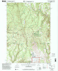
~ Knox Mountain OR topo map, 1:24000 scale, 7.5 X 7.5 Minute, Historical, 1999, updated 2002
Knox Mountain, Oregon, USGS topographic map dated 1999.
Includes geographic coordinates (latitude and longitude). This topographic map is suitable for hiking, camping, and exploring, or framing it as a wall map.
Printed on-demand using high resolution imagery, on heavy weight and acid free paper, or alternatively on a variety of synthetic materials.
Topos available on paper, Waterproof, Poly, or Tyvek. Usually shipping rolled, unless combined with other folded maps in one order.
- Product Number: USGS-5419452
- Free digital map download (high-resolution, GeoPDF): Knox Mountain, Oregon (file size: 15 MB)
- Map Size: please refer to the dimensions of the GeoPDF map above
- Weight (paper map): ca. 55 grams
- Map Type: POD USGS Topographic Map
- Map Series: HTMC
- Map Verison: Historical
- Cell ID: 23899
- Scan ID: 280417
- Imprint Year: 2002
- Woodland Tint: Yes
- Aerial Photo Year: 1969
- Field Check Year: 1994
- Datum: NAD27
- Map Projection: Lambert Conformal Conic
- Map published by United States Geological Survey
- Map published by United States Forest Service
- Map Language: English
- Scanner Resolution: 600 dpi
- Map Cell Name: Knox Mountain
- Grid size: 7.5 X 7.5 Minute
- Date on map: 1999
- Map Scale: 1:24000
- Geographical region: Oregon, United States
Neighboring Maps:
All neighboring USGS topo maps are available for sale online at a variety of scales.
Spatial coverage:
Topo map Knox Mountain, Oregon, covers the geographical area associated the following places:
- Palmer Spring - Juniper Spring - Swale Springs - Teepee Spring - Buttermilk Flat - Cottonwood Spring - Westfall Spring - Fir Tree Spring - Knox Mountain - Cougar Spring - Hoffman Spring - Cougar Meadow - Two Dot Spring - Shorty Reservoir - Miller and Jackson Spring - Tuck Reservoir - Alder Spring - Blue Bucket Cow Camp - Ott Cow Camp - Tamarack Spring - Alder Creek - Hogan Spring - Jones Spring - Bingham Spring - Marksbury Spring - Alder Spring - Tamarack Reservoir - Antelope Lookout Tower - Antelope Swale - Bear Spring - Lost Spring - Moffitt Spring - Cat Creek - Knox Meadow - Cougar Creek - Antelope Mountain - Whitney Spring - Cabin Spring - Leacy Spring
- Map Area ID: AREA44.12544-118.5-118.375
- Northwest corner Lat/Long code: USGSNW44.125-118.5
- Northeast corner Lat/Long code: USGSNE44.125-118.375
- Southwest corner Lat/Long code: USGSSW44-118.5
- Southeast corner Lat/Long code: USGSSE44-118.375
- Northern map edge Latitude: 44.125
- Southern map edge Latitude: 44
- Western map edge Longitude: -118.5
- Eastern map edge Longitude: -118.375


