
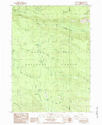
~ Imnaha Creek OR topo map, 1:24000 scale, 7.5 X 7.5 Minute, Historical, 1985, updated 1986
Imnaha Creek, Oregon, USGS topographic map dated 1985.
Includes geographic coordinates (latitude and longitude). This topographic map is suitable for hiking, camping, and exploring, or framing it as a wall map.
Printed on-demand using high resolution imagery, on heavy weight and acid free paper, or alternatively on a variety of synthetic materials.
Topos available on paper, Waterproof, Poly, or Tyvek. Usually shipping rolled, unless combined with other folded maps in one order.
- Product Number: USGS-5419194
- Free digital map download (high-resolution, GeoPDF): Imnaha Creek, Oregon (file size: 12 MB)
- Map Size: please refer to the dimensions of the GeoPDF map above
- Weight (paper map): ca. 55 grams
- Map Type: POD USGS Topographic Map
- Map Series: HTMC
- Map Verison: Historical
- Cell ID: 21739
- Scan ID: 280283
- Imprint Year: 1986
- Woodland Tint: Yes
- Aerial Photo Year: 1982
- Edit Year: 1985
- Field Check Year: 1982
- Datum: NAD27
- Map Projection: Lambert Conformal Conic
- Provisional map: Yes
- Map published by United States Geological Survey
- Map Language: English
- Scanner Resolution: 600 dpi
- Map Cell Name: Imnaha Creek
- Grid size: 7.5 X 7.5 Minute
- Date on map: 1985
- Map Scale: 1:24000
- Geographical region: Oregon, United States
Neighboring Maps:
All neighboring USGS topo maps are available for sale online at a variety of scales.
Spatial coverage:
Topo map Imnaha Creek, Oregon, covers the geographical area associated the following places:
- Frey Creek - Big Ben Creek - Sumpter Creek - Otter Spring - South Fork Wallowa Creek - Hemlock Spring - Halifax Creek - Frog Lake - King Spruce Camp - Bessie Rock Trail - Sam Creek - Green Creek - Aspen Spring - Fire Creek - King Spruce Trail - Mudjekeewis Trail - South Fork Recreation Site - Spring Creek - Lookout Gulch - Lodgepole Creek - Black Bear Swamp - Rogue River National Forest - Foot Creek - Fantail Spring - Sumpter Creek Camp (historical) - Kerby Creek - Whitman Creek - North Fork Wallowa Creek - Fire Spring - Fall Creek - Geyser Spring - Mudjekeewis Mountain - Nichols Camp (historical) - Imnaha Guard Station - Imnaha Recreation Site - Kerby Hill - Nichols Creek - Big Ben Campground (historical) - Hemlock Lake Trail - Seven Lakes Trail - Fantail Creek - Snowbrush Gulch - Wallowa Creek
- Map Area ID: AREA42.7542.625-122.375-122.25
- Northwest corner Lat/Long code: USGSNW42.75-122.375
- Northeast corner Lat/Long code: USGSNE42.75-122.25
- Southwest corner Lat/Long code: USGSSW42.625-122.375
- Southeast corner Lat/Long code: USGSSE42.625-122.25
- Northern map edge Latitude: 42.75
- Southern map edge Latitude: 42.625
- Western map edge Longitude: -122.375
- Eastern map edge Longitude: -122.25


