
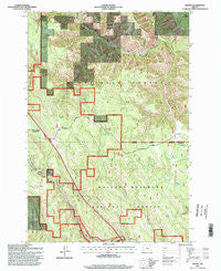
~ Huron OR topo map, 1:24000 scale, 7.5 X 7.5 Minute, Historical, 1995, updated 1998
Huron, Oregon, USGS topographic map dated 1995.
Includes geographic coordinates (latitude and longitude). This topographic map is suitable for hiking, camping, and exploring, or framing it as a wall map.
Printed on-demand using high resolution imagery, on heavy weight and acid free paper, or alternatively on a variety of synthetic materials.
Topos available on paper, Waterproof, Poly, or Tyvek. Usually shipping rolled, unless combined with other folded maps in one order.
- Product Number: USGS-5419166
- Free digital map download (high-resolution, GeoPDF): Huron, Oregon (file size: 20 MB)
- Map Size: please refer to the dimensions of the GeoPDF map above
- Weight (paper map): ca. 55 grams
- Map Type: POD USGS Topographic Map
- Map Series: HTMC
- Map Verison: Historical
- Cell ID: 21567
- Scan ID: 280269
- Imprint Year: 1998
- Woodland Tint: Yes
- Aerial Photo Year: 1994
- Field Check Year: 1995
- Datum: NAD27
- Map Projection: Lambert Conformal Conic
- Map published by United States Geological Survey
- Map published by United States Forest Service
- Map Language: English
- Scanner Resolution: 600 dpi
- Map Cell Name: Huron
- Grid size: 7.5 X 7.5 Minute
- Date on map: 1995
- Map Scale: 1:24000
- Geographical region: Oregon, United States
Neighboring Maps:
All neighboring USGS topo maps are available for sale online at a variety of scales.
Spatial coverage:
Topo map Huron, Oregon, covers the geographical area associated the following places:
- Rugg Cabin - Butcher Creek - California Gulch - Lansing Spring - Bodie (historical) - Reardon Siding (historical) - Wells Spring - Camp - Owsley Creek - Rock Spring - Tie Creek - Tillicum Creek - Huron - Butcher Point - Motanic - Laka (historical) - Rugg Cemetery - East Meacham Creek - Owsley Hogback - Butcher Knife Spring - Ridgetop Pond - Short Canyon - Fowler Spring - Rugg Spring - Oregon Trail Interpretive Park - Fox Prairie - Nunamaker Pond - Allen Creek - Four Horse Smith Spring - Ruddock Post Office (historical) - Walker Ridge - Red Saddle - Nunamaker Spring - Pack Rat Spring - Huron Post Office (historical) - Strickland Flat - Allens Spur (historical)
- Map Area ID: AREA45.545.375-118.375-118.25
- Northwest corner Lat/Long code: USGSNW45.5-118.375
- Northeast corner Lat/Long code: USGSNE45.5-118.25
- Southwest corner Lat/Long code: USGSSW45.375-118.375
- Southeast corner Lat/Long code: USGSSE45.375-118.25
- Northern map edge Latitude: 45.5
- Southern map edge Latitude: 45.375
- Western map edge Longitude: -118.375
- Eastern map edge Longitude: -118.25


