
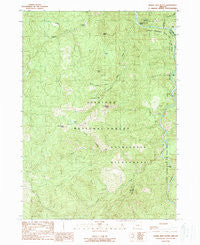
~ Horse Sign Butte OR topo map, 1:24000 scale, 7.5 X 7.5 Minute, Historical, 1989, updated 1989
Horse Sign Butte, Oregon, USGS topographic map dated 1989.
Includes geographic coordinates (latitude and longitude). This topographic map is suitable for hiking, camping, and exploring, or framing it as a wall map.
Printed on-demand using high resolution imagery, on heavy weight and acid free paper, or alternatively on a variety of synthetic materials.
Topos available on paper, Waterproof, Poly, or Tyvek. Usually shipping rolled, unless combined with other folded maps in one order.
- Product Number: USGS-5419124
- Free digital map download (high-resolution, GeoPDF): Horse Sign Butte, Oregon (file size: 18 MB)
- Map Size: please refer to the dimensions of the GeoPDF map above
- Weight (paper map): ca. 55 grams
- Map Type: POD USGS Topographic Map
- Map Series: HTMC
- Map Verison: Historical
- Cell ID: 21095
- Scan ID: 280248
- Imprint Year: 1989
- Woodland Tint: Yes
- Aerial Photo Year: 1984
- Edit Year: 1989
- Field Check Year: 1986
- Datum: NAD27
- Map Projection: Lambert Conformal Conic
- Provisional map: Yes
- Map published by United States Geological Survey
- Map Language: English
- Scanner Resolution: 600 dpi
- Map Cell Name: Horse Sign Butte
- Grid size: 7.5 X 7.5 Minute
- Date on map: 1989
- Map Scale: 1:24000
- Geographical region: Oregon, United States
Neighboring Maps:
All neighboring USGS topo maps are available for sale online at a variety of scales.
Spatial coverage:
Topo map Horse Sign Butte, Oregon, covers the geographical area associated the following places:
- Horse Sign Creek - North Fork Collier Creek - Silver Creek - Game Lake - Sourdough Camp (historical) - Bluff Creek - Burt Camp - Horse Sign Creek Rapids - Game Lake Lookout (historical) - Forest Creek - Horse Sign Butte - Brandon Camp - South Fork Collier Creek - Pine Flat Creek - Black Rock Creek - Collier Bar - Buzzards Roost - Lawson Butte - Fry Place - Illinois National Wild and Scenic River - Indian Flat - Conners Place - Sizeable Stream - Game Lake Recreation Site - Hurt Cabin - Indigo Creek
- Map Area ID: AREA42.542.375-124.125-124
- Northwest corner Lat/Long code: USGSNW42.5-124.125
- Northeast corner Lat/Long code: USGSNE42.5-124
- Southwest corner Lat/Long code: USGSSW42.375-124.125
- Southeast corner Lat/Long code: USGSSE42.375-124
- Northern map edge Latitude: 42.5
- Southern map edge Latitude: 42.375
- Western map edge Longitude: -124.125
- Eastern map edge Longitude: -124


