
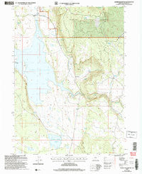
~ Gerber Reservoir OR topo map, 1:24000 scale, 7.5 X 7.5 Minute, Historical, 2004, updated 2007
Gerber Reservoir, Oregon, USGS topographic map dated 2004.
Includes geographic coordinates (latitude and longitude). This topographic map is suitable for hiking, camping, and exploring, or framing it as a wall map.
Printed on-demand using high resolution imagery, on heavy weight and acid free paper, or alternatively on a variety of synthetic materials.
Topos available on paper, Waterproof, Poly, or Tyvek. Usually shipping rolled, unless combined with other folded maps in one order.
- Product Number: USGS-5418656
- Free digital map download (high-resolution, GeoPDF): Gerber Reservoir, Oregon (file size: 11 MB)
- Map Size: please refer to the dimensions of the GeoPDF map above
- Weight (paper map): ca. 55 grams
- Map Type: POD USGS Topographic Map
- Map Series: HTMC
- Map Verison: Historical
- Cell ID: 17105
- Scan ID: 280009
- Imprint Year: 2007
- Woodland Tint: Yes
- Aerial Photo Year: 2000
- Edit Year: 2004
- Datum: NAD83
- Map Projection: Universal Transverse Mercator
- Map published by United States Geological Survey
- Map published by United States Forest Service
- Map Language: English
- Scanner Resolution: 600 dpi
- Map Cell Name: Gerber Reservoir
- Grid size: 7.5 X 7.5 Minute
- Date on map: 2004
- Map Scale: 1:24000
- Geographical region: Oregon, United States
Neighboring Maps:
All neighboring USGS topo maps are available for sale online at a variety of scales.
Spatial coverage:
Topo map Gerber Reservoir, Oregon, covers the geographical area associated the following places:
- Barnes Valley Creek - Norcross Spring - Casebeer Spring - J Spring - South Gerber Campground Boat Ramp - Round Valley Dam - Barnes Valley Boat Launch - Wagon Road Spring - Long Branch Creek - Coulter Spring - Wildhorse Recreation Site - Casebeer Ranch - Horsefly Reservoir - Three C Spring - Pitch Log Recreation Site - O'Shea Cabin - Gerber Reservoir - Barnes Valley Boat Ramp - Frog Camp Recreation Site - Moonshine Spring - Barnes Creek - Boundary Spring - O'Shea Spring - Wildhorse Creek - Pitch Log Creek - Caseview Spring - Round Valley Reservoir - Mud Spring - Long Branch Spring
- Map Area ID: AREA42.2542.125-121.125-121
- Northwest corner Lat/Long code: USGSNW42.25-121.125
- Northeast corner Lat/Long code: USGSNE42.25-121
- Southwest corner Lat/Long code: USGSSW42.125-121.125
- Southeast corner Lat/Long code: USGSSE42.125-121
- Northern map edge Latitude: 42.25
- Southern map edge Latitude: 42.125
- Western map edge Longitude: -121.125
- Eastern map edge Longitude: -121


