
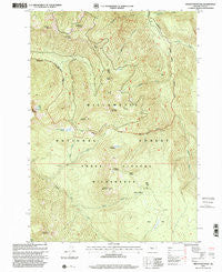
~ French Mountain OR topo map, 1:24000 scale, 7.5 X 7.5 Minute, Historical, 1997, updated 2001
French Mountain, Oregon, USGS topographic map dated 1997.
Includes geographic coordinates (latitude and longitude). This topographic map is suitable for hiking, camping, and exploring, or framing it as a wall map.
Printed on-demand using high resolution imagery, on heavy weight and acid free paper, or alternatively on a variety of synthetic materials.
Topos available on paper, Waterproof, Poly, or Tyvek. Usually shipping rolled, unless combined with other folded maps in one order.
- Product Number: USGS-5418554
- Free digital map download (high-resolution, GeoPDF): French Mountain, Oregon (file size: 17 MB)
- Map Size: please refer to the dimensions of the GeoPDF map above
- Weight (paper map): ca. 55 grams
- Map Type: POD USGS Topographic Map
- Map Series: HTMC
- Map Verison: Historical
- Cell ID: 16424
- Scan ID: 279958
- Imprint Year: 2001
- Woodland Tint: Yes
- Aerial Photo Year: 1995
- Edit Year: 1997
- Datum: NAD27
- Map Projection: Lambert Conformal Conic
- Map published by United States Geological Survey
- Map published by United States Forest Service
- Map Language: English
- Scanner Resolution: 600 dpi
- Map Cell Name: French Mountain
- Grid size: 7.5 X 7.5 Minute
- Date on map: 1997
- Map Scale: 1:24000
- Geographical region: Oregon, United States
Neighboring Maps:
All neighboring USGS topo maps are available for sale online at a variety of scales.
Spatial coverage:
Topo map French Mountain, Oregon, covers the geographical area associated the following places:
- Pothole Meadow - Pothole Creek - Mosquito Creek - Wolverine Meadow - Pat Creek - Olallie Trail - Quaking Aspen Swamp - Horsepasture Mountain - Aspen Creek - Olallie Meadows - English Mountain - Lamb Butte - Karl Lake - Horsepasture Pass Shelter (historical) - Eugene Creek - Roney Creek - The Potholes - Ruth Lake - Saddle Trail - Pyramid Mountain - Separation Creek - Pasture Creek - French Mountain - Olallie Guard Station - Olallie Mountain - Bear Flat - O'Leary Mountain - Castle Creek - Olallie Creek - Louise Creek - Pyramid Trail - Taylor Castle
- Map Area ID: AREA44.12544-122.125-122
- Northwest corner Lat/Long code: USGSNW44.125-122.125
- Northeast corner Lat/Long code: USGSNE44.125-122
- Southwest corner Lat/Long code: USGSSW44-122.125
- Southeast corner Lat/Long code: USGSSE44-122
- Northern map edge Latitude: 44.125
- Southern map edge Latitude: 44
- Western map edge Longitude: -122.125
- Eastern map edge Longitude: -122


