
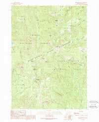
~ Fish Mountain OR topo map, 1:24000 scale, 7.5 X 7.5 Minute, Historical, 1989, updated 1990
Fish Mountain, Oregon, USGS topographic map dated 1989.
Includes geographic coordinates (latitude and longitude). This topographic map is suitable for hiking, camping, and exploring, or framing it as a wall map.
Printed on-demand using high resolution imagery, on heavy weight and acid free paper, or alternatively on a variety of synthetic materials.
Topos available on paper, Waterproof, Poly, or Tyvek. Usually shipping rolled, unless combined with other folded maps in one order.
- Product Number: USGS-5418384
- Free digital map download (high-resolution, GeoPDF): Fish Mountain, Oregon (file size: 16 MB)
- Map Size: please refer to the dimensions of the GeoPDF map above
- Weight (paper map): ca. 55 grams
- Map Type: POD USGS Topographic Map
- Map Series: HTMC
- Map Verison: Historical
- Cell ID: 15343
- Scan ID: 279873
- Imprint Year: 1990
- Woodland Tint: Yes
- Aerial Photo Year: 1980
- Edit Year: 1989
- Field Check Year: 1984
- Datum: NAD27
- Map Projection: Lambert Conformal Conic
- Provisional map: Yes
- Map published by United States Geological Survey
- Map Language: English
- Scanner Resolution: 600 dpi
- Map Cell Name: Fish Mountain
- Grid size: 7.5 X 7.5 Minute
- Date on map: 1989
- Map Scale: 1:24000
- Geographical region: Oregon, United States
Neighboring Maps:
All neighboring USGS topo maps are available for sale online at a variety of scales.
Spatial coverage:
Topo map Fish Mountain, Oregon, covers the geographical area associated the following places:
- Hole in the Ground - Toad Lake - Poole Lake - Wiley Creek - Horse Creek - Mosquito Lake - Hunter Creek - Buck Canyon Trail - Bear Camp - Meadow Creek Trail - Wiley Camp - Highrock Mountain - Rogue-Umpqua Divide Wilderness - Alkali Meadows - Alkali Camp - Fish Mountain - Log Pile Trail - Windy Gap - Hershberger Mountain - Fish Lake Trail - Rabbit Ears - Foster Glades - Pup Prairie - Fish Creek Valley - High Prairie - Jackass Mountain - Hummingbird Creek - Triangle Lake - Highrock Creek - Slide Creek - Lewis Camp - Rattlesnake Mountain - Fish Creek Shelter - Log Creek - Buckneck Mountain - Rocky Ridge - Castle Rock - Devils Slide - Gale Creek - Weaver Mountain
- Map Area ID: AREA43.12543-122.5-122.375
- Northwest corner Lat/Long code: USGSNW43.125-122.5
- Northeast corner Lat/Long code: USGSNE43.125-122.375
- Southwest corner Lat/Long code: USGSSW43-122.5
- Southeast corner Lat/Long code: USGSSE43-122.375
- Northern map edge Latitude: 43.125
- Southern map edge Latitude: 43
- Western map edge Longitude: -122.5
- Eastern map edge Longitude: -122.375


