
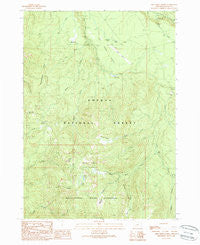
~ Fish Creek Desert OR topo map, 1:24000 scale, 7.5 X 7.5 Minute, Historical, 1989, updated 1990
Fish Creek Desert, Oregon, USGS topographic map dated 1989.
Includes geographic coordinates (latitude and longitude). This topographic map is suitable for hiking, camping, and exploring, or framing it as a wall map.
Printed on-demand using high resolution imagery, on heavy weight and acid free paper, or alternatively on a variety of synthetic materials.
Topos available on paper, Waterproof, Poly, or Tyvek. Usually shipping rolled, unless combined with other folded maps in one order.
- Product Number: USGS-5418366
- Free digital map download (high-resolution, GeoPDF): Fish Creek Desert, Oregon (file size: 15 MB)
- Map Size: please refer to the dimensions of the GeoPDF map above
- Weight (paper map): ca. 55 grams
- Map Type: POD USGS Topographic Map
- Map Series: HTMC
- Map Verison: Historical
- Cell ID: 15329
- Scan ID: 279864
- Imprint Year: 1990
- Woodland Tint: Yes
- Aerial Photo Year: 1980
- Edit Year: 1989
- Field Check Year: 1984
- Datum: NAD27
- Map Projection: Lambert Conformal Conic
- Provisional map: Yes
- Map published by United States Geological Survey
- Map Language: English
- Scanner Resolution: 600 dpi
- Map Cell Name: Fish Creek Desert
- Grid size: 7.5 X 7.5 Minute
- Date on map: 1989
- Map Scale: 1:24000
- Geographical region: Oregon, United States
Neighboring Maps:
All neighboring USGS topo maps are available for sale online at a variety of scales.
Spatial coverage:
Topo map Fish Creek Desert, Oregon, covers the geographical area associated the following places:
- Rhododendron Ridge - Slipper Creek - Grave Creek Trail - No Tunnel Creek - Black Rock Creek - Toketee State Airport - Big Camp Ranger Station (historical) - Fawn Lake - Grave Creek - Rough Creek - Mud Lake Mountain - Rolling Grounds - Wolf Lake - Fish Creek Reservoir - Quartz Canyon - Pine Creek - Black Rock Trail - Cedar Spring - Camas Creek Campground - Camas Creek - Eva Creek - Clear Creek - Beaver Shelter - Rattlesnake Way - Fawn Creek - Black Rock - Greek Creek - Brodie Creek - Whitehorse Meadows - Fish Creek Campground - Rolling Grounds Camp - The Jumpoff - Watson Falls - Happy Valley - Fish Creek Desert - Fish Creek Dam - French Junction - Fish Creek Canal - Watson Falls Recreation Site
- Map Area ID: AREA43.2543.125-122.5-122.375
- Northwest corner Lat/Long code: USGSNW43.25-122.5
- Northeast corner Lat/Long code: USGSNE43.25-122.375
- Southwest corner Lat/Long code: USGSSW43.125-122.5
- Southeast corner Lat/Long code: USGSSE43.125-122.375
- Northern map edge Latitude: 43.25
- Southern map edge Latitude: 43.125
- Western map edge Longitude: -122.5
- Eastern map edge Longitude: -122.375


