
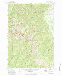
~ Elkhorn Peak OR topo map, 1:24000 scale, 7.5 X 7.5 Minute, Historical, 1972, updated 1984
Elkhorn Peak, Oregon, USGS topographic map dated 1972.
Includes geographic coordinates (latitude and longitude). This topographic map is suitable for hiking, camping, and exploring, or framing it as a wall map.
Printed on-demand using high resolution imagery, on heavy weight and acid free paper, or alternatively on a variety of synthetic materials.
Topos available on paper, Waterproof, Poly, or Tyvek. Usually shipping rolled, unless combined with other folded maps in one order.
- Product Number: USGS-5418216
- Free digital map download (high-resolution, GeoPDF): Elkhorn Peak, Oregon (file size: 18 MB)
- Map Size: please refer to the dimensions of the GeoPDF map above
- Weight (paper map): ca. 55 grams
- Map Type: POD USGS Topographic Map
- Map Series: HTMC
- Map Verison: Historical
- Cell ID: 14047
- Scan ID: 279788
- Imprint Year: 1984
- Woodland Tint: Yes
- Aerial Photo Year: 1971
- Field Check Year: 1972
- Datum: NAD27
- Map Projection: Lambert Conformal Conic
- Map published by United States Geological Survey
- Map Language: English
- Scanner Resolution: 600 dpi
- Map Cell Name: Elkhorn Peak
- Grid size: 7.5 X 7.5 Minute
- Date on map: 1972
- Map Scale: 1:24000
- Geographical region: Oregon, United States
Neighboring Maps:
All neighboring USGS topo maps are available for sale online at a variety of scales.
Spatial coverage:
Topo map Elkhorn Peak, Oregon, covers the geographical area associated the following places:
- South Prong Pine Creek - Little Marble Creek - Cougar Pond - Cougar Basin - Rock Creek Lake - Elkhorn Crest Trail - Goodrich Dam - Little Mill Creek - North Fork Pine Creek - Marble Point - Bear Creek - Elkhorn Peak - West Fork Lake Creek - Crevice Creek - South Fork Rock Creek - Tracy Post Office (historical) - Middle Camp Baisley-Elkhorn Mine - Highland Mine - Goodrich Lake - Excuse Mine - Nelson Ditch - Marble Creek Recreation Site - Rock Creek Butte - Rock Lake Dam - Twin Lakes Trail - Hunt Mountain - Pine Creek Dam - Bucket Lake - Hawk Spring - Twin Lakes - Pine Creek Reservoir - Lower Baisley-Elkhorn Mine - Gee Creek - Highland Trail - Gee Creek Swamp - Maxwell Mine - Eilertson Meadow - Upper Baisley-Elkhorn Mine - Elkhorn Ridge - Camp Lee - Coyote Spring - Willow Creek Lake - Williams Ditch
- Map Area ID: AREA44.87544.75-118.125-118
- Northwest corner Lat/Long code: USGSNW44.875-118.125
- Northeast corner Lat/Long code: USGSNE44.875-118
- Southwest corner Lat/Long code: USGSSW44.75-118.125
- Southeast corner Lat/Long code: USGSSE44.75-118
- Northern map edge Latitude: 44.875
- Southern map edge Latitude: 44.75
- Western map edge Longitude: -118.125
- Eastern map edge Longitude: -118


