
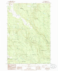
~ Elk Prairie OR topo map, 1:24000 scale, 7.5 X 7.5 Minute, Historical, 1985, updated 1986
Elk Prairie, Oregon, USGS topographic map dated 1985.
Includes geographic coordinates (latitude and longitude). This topographic map is suitable for hiking, camping, and exploring, or framing it as a wall map.
Printed on-demand using high resolution imagery, on heavy weight and acid free paper, or alternatively on a variety of synthetic materials.
Topos available on paper, Waterproof, Poly, or Tyvek. Usually shipping rolled, unless combined with other folded maps in one order.
- Product Number: USGS-5418214
- Free digital map download (high-resolution, GeoPDF): Elk Prairie, Oregon (file size: 12 MB)
- Map Size: please refer to the dimensions of the GeoPDF map above
- Weight (paper map): ca. 55 grams
- Map Type: POD USGS Topographic Map
- Map Series: HTMC
- Map Verison: Historical
- Cell ID: 14009
- Scan ID: 279787
- Imprint Year: 1986
- Woodland Tint: Yes
- Aerial Photo Year: 1982
- Edit Year: 1985
- Field Check Year: 1983
- Datum: NAD27
- Map Projection: Lambert Conformal Conic
- Provisional map: Yes
- Map published by United States Geological Survey
- Map Language: English
- Scanner Resolution: 600 dpi
- Map Cell Name: Elk Prairie
- Grid size: 7.5 X 7.5 Minute
- Date on map: 1985
- Map Scale: 1:24000
- Geographical region: Oregon, United States
Neighboring Maps:
All neighboring USGS topo maps are available for sale online at a variety of scales.
Spatial coverage:
Topo map Elk Prairie, Oregon, covers the geographical area associated the following places:
- Camp Peterson - Crooked Finger Prairie - Abiqua Falls - Elk Prairie School (historical) - Silverton Fire District Station 9 Scotts Mills - Homestead Creek - Upper North Falls - Johnston Creek - Deardorff Reservoir - Bucket Creek - Kirk Creek - Middle Fork Cedar Creek - Elk Prairie - Little Coal Creek - Bridge Creek Post Office (historical) - Priest Creek - Moss Lake - Abiqua Basin - Goober Creek - Looney Creek - Marion County - Little North Fork Silver Creek - North Falls - Betty Jane Deardorff Dam - Cedar Camp Post Office (historical) - Butte Creek Falls - Fall Creek Falls - Holy Rosary Church - North Fork Cedar Creek - Trinity Falls Creek - South Forks Falls Creek - Holy Rosary Cemetery - Abiqua Lake - Meyers Butte - Fall Creek - Crooked Finger School (historical) - Abiqua Creek Park - South Fork Cedar Creek - Kautz Mansion - Cedar Creek - Bridge Creek
- Map Area ID: AREA4544.875-122.625-122.5
- Northwest corner Lat/Long code: USGSNW45-122.625
- Northeast corner Lat/Long code: USGSNE45-122.5
- Southwest corner Lat/Long code: USGSSW44.875-122.625
- Southeast corner Lat/Long code: USGSSE44.875-122.5
- Northern map edge Latitude: 45
- Southern map edge Latitude: 44.875
- Western map edge Longitude: -122.625
- Eastern map edge Longitude: -122.5


