
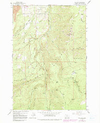
~ Dog River OR topo map, 1:24000 scale, 7.5 X 7.5 Minute, Historical, 1962, updated 1991
Dog River, Oregon, USGS topographic map dated 1962.
Includes geographic coordinates (latitude and longitude). This topographic map is suitable for hiking, camping, and exploring, or framing it as a wall map.
Printed on-demand using high resolution imagery, on heavy weight and acid free paper, or alternatively on a variety of synthetic materials.
Topos available on paper, Waterproof, Poly, or Tyvek. Usually shipping rolled, unless combined with other folded maps in one order.
- Product Number: USGS-5417966
- Free digital map download (high-resolution, GeoPDF): Dog River, Oregon (file size: 13 MB)
- Map Size: please refer to the dimensions of the GeoPDF map above
- Weight (paper map): ca. 55 grams
- Map Type: POD USGS Topographic Map
- Map Series: HTMC
- Map Verison: Historical
- Cell ID: 12460
- Scan ID: 279664
- Imprint Year: 1991
- Woodland Tint: Yes
- Photo Revision Year: 1979
- Aerial Photo Year: 1974
- Edit Year: 1979
- Field Check Year: 1962
- Datum: NAD27
- Map Projection: Polyconic
- Map published by United States Geological Survey
- Map Language: English
- Scanner Resolution: 600 dpi
- Map Cell Name: Dog River
- Grid size: 7.5 X 7.5 Minute
- Date on map: 1962
- Map Scale: 1:24000
- Geographical region: Oregon, United States
Neighboring Maps:
All neighboring USGS topo maps are available for sale online at a variety of scales.
Spatial coverage:
Topo map Dog River, Oregon, covers the geographical area associated the following places:
- Tumble Creek - Evans Creek Quarry - Polallie Campground (historical) - Dog River - Clinger Campground - Dog River Trail - Shellrock Mountain - Ash Creek - Crystal Spring Creek - Gibson Prairie - Parkdale Division - Culvert Creek - Buck Creek - Cold Spring Creek - Agnes Spring - Cooks Meadow - Glacier Ditch - Zigzag Trail - Elk Bed Springs - Routson County Park - Ditch Creek - Lamberson Butte Spur Trail - Shinners English Spring - Kiyokawa Family Orchards - Cat Creek - Brooks Meadow - North Fork Cold Spring Creek - Polallie Creek - Horkelia Meadow - Mill Creek Buttes - Watershed Quarry - Sherwood Recreation Site - Roaring Camp Spring - Sparks Spring - Shellrock Spring - Powder Springs - Doe Creek - Tilly Jane Creek - Puppy Creek - Ward Creek - The Dalles City Waterworks - Crystal Spring - Bottle Prairie - Blue Bucket Spring - Fall Creek - Rim Rock - Hannum Spring - Blue Bucket Trail - Rimrock Creek - Tamanawas Falls - Weygandt Canyon - Cooper Spur Ski Area - Gibson Spring - Clinger Spring - Brooks Meadow Guard Station - Gibson Prairie Horse Camp - Sand Canyon - West Fork Evans Creek - Volmer Ditch
- Map Area ID: AREA45.545.375-121.625-121.5
- Northwest corner Lat/Long code: USGSNW45.5-121.625
- Northeast corner Lat/Long code: USGSNE45.5-121.5
- Southwest corner Lat/Long code: USGSSW45.375-121.625
- Southeast corner Lat/Long code: USGSSE45.375-121.5
- Northern map edge Latitude: 45.5
- Southern map edge Latitude: 45.375
- Western map edge Longitude: -121.625
- Eastern map edge Longitude: -121.5


