
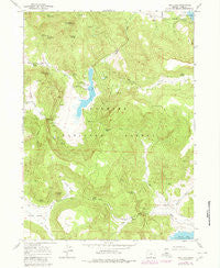
~ Dog Lake OR topo map, 1:24000 scale, 7.5 X 7.5 Minute, Historical, 1964, updated 1980
Dog Lake, Oregon, USGS topographic map dated 1964.
Includes geographic coordinates (latitude and longitude). This topographic map is suitable for hiking, camping, and exploring, or framing it as a wall map.
Printed on-demand using high resolution imagery, on heavy weight and acid free paper, or alternatively on a variety of synthetic materials.
Topos available on paper, Waterproof, Poly, or Tyvek. Usually shipping rolled, unless combined with other folded maps in one order.
- Product Number: USGS-5417956
- Free digital map download (high-resolution, GeoPDF): Dog Lake, Oregon (file size: 14 MB)
- Map Size: please refer to the dimensions of the GeoPDF map above
- Weight (paper map): ca. 55 grams
- Map Type: POD USGS Topographic Map
- Map Series: HTMC
- Map Verison: Historical
- Cell ID: 12453
- Scan ID: 279659
- Imprint Year: 1980
- Woodland Tint: Yes
- Photo Revision Year: 1980
- Aerial Photo Year: 1979
- Edit Year: 1980
- Field Check Year: 1964
- Datum: NAD27
- Map Projection: Polyconic
- Map published by United States Geological Survey
- Map Language: English
- Scanner Resolution: 600 dpi
- Map Cell Name: Dog Lake
- Grid size: 7.5 X 7.5 Minute
- Date on map: 1964
- Map Scale: 1:24000
- Geographical region: Oregon, United States
Neighboring Maps:
All neighboring USGS topo maps are available for sale online at a variety of scales.
Spatial coverage:
Topo map Dog Lake, Oregon, covers the geographical area associated the following places:
- Slash Spring - Campground Number One (historical) - Dog Lake Burn Spring - Horseshoe Creek - Scotts Cabin Creek - Campground Number Two (historical) - Mine Spring - Dog Lake Work Center - Big Dog Spring - Dog Lake Recreation Site - Cold Spring - Little Dog Spring - McCoin Creek - Castle Rock - Hunter Spring - Green Creek - Jerry Spring - Dog Mountain Creek - Buckaroo Pass - Dog Lake - Little Lakes - White Spring - Upper Road Spring - Ross Ranch - South Arm Yokum Valley - Dog Mountain - Adams Spring - Telephone Spring - Kitty Spring - Dog Lake Spring - Dog Lake Guard Station - Young Valley - Nick Barry Spring - Fred Ross - Fall Valley - Navy Spring - Scotts Cabin Spring - Dog Lake Campground Boat Ramp - Fall Creek - Green Valley
- Map Area ID: AREA42.12542-120.75-120.625
- Northwest corner Lat/Long code: USGSNW42.125-120.75
- Northeast corner Lat/Long code: USGSNE42.125-120.625
- Southwest corner Lat/Long code: USGSSW42-120.75
- Southeast corner Lat/Long code: USGSSE42-120.625
- Northern map edge Latitude: 42.125
- Southern map edge Latitude: 42
- Western map edge Longitude: -120.75
- Eastern map edge Longitude: -120.625


