
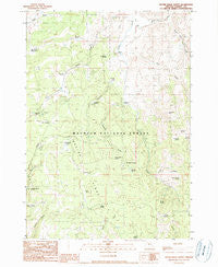
~ Devine Ridge North OR topo map, 1:24000 scale, 7.5 X 7.5 Minute, Historical, 1990, updated 1990
Devine Ridge North, Oregon, USGS topographic map dated 1990.
Includes geographic coordinates (latitude and longitude). This topographic map is suitable for hiking, camping, and exploring, or framing it as a wall map.
Printed on-demand using high resolution imagery, on heavy weight and acid free paper, or alternatively on a variety of synthetic materials.
Topos available on paper, Waterproof, Poly, or Tyvek. Usually shipping rolled, unless combined with other folded maps in one order.
- Product Number: USGS-5417896
- Free digital map download (high-resolution, GeoPDF): Devine Ridge North, Oregon (file size: 11 MB)
- Map Size: please refer to the dimensions of the GeoPDF map above
- Weight (paper map): ca. 55 grams
- Map Type: POD USGS Topographic Map
- Map Series: HTMC
- Map Verison: Historical
- Cell ID: 12129
- Scan ID: 279629
- Imprint Year: 1990
- Woodland Tint: Yes
- Aerial Photo Year: 1984
- Edit Year: 1990
- Field Check Year: 1986
- Datum: NAD27
- Map Projection: Lambert Conformal Conic
- Provisional map: Yes
- Map published by United States Geological Survey
- Map Language: English
- Scanner Resolution: 600 dpi
- Map Cell Name: Devine Ridge North
- Grid size: 7.5 X 7.5 Minute
- Date on map: 1990
- Map Scale: 1:24000
- Geographical region: Oregon, United States
Neighboring Maps:
All neighboring USGS topo maps are available for sale online at a variety of scales.
Spatial coverage:
Topo map Devine Ridge North, Oregon, covers the geographical area associated the following places:
- Marshall Spring - Gobblers Knob - Powerline Spring - Cold Spring - Shott Spring - Roach Creek - Parker Spring - King Spring - Baker Corral - Roach Creek Spring - Rock Spring - Strawberry Spring - Idol Post Office (historical) - Boy Scout Cabin - Summit (historical) - Crow Flat Guard Station - Van Zandt Meadows - Temple Ranch - Hardesty Ranch - Kid Flat Spring - Tommys Spring - Idol City Mines - Lonesomehurst Post Office (historical) - Ponderosa Spring - Hi Desert Ski Area (historical) - Devine Ridge - R K Spring - Marshall Creek - Williams Field - Dickenson Ranch - Flying W Spring - RIL Spring - Cross Ranch - Strawberry Creek - Larsen Spring - Crow Flat - Pardee Spring - South Fork Trout Creek - Purdy Ranch - Three-Seven Spring - Nelson Ranch - East Creek - Sand Spring - Idlewild Recreation Site - Abraham Spring - North Fork Trout Creek - Mud Spring
- Map Area ID: AREA43.87543.75-119-118.875
- Northwest corner Lat/Long code: USGSNW43.875-119
- Northeast corner Lat/Long code: USGSNE43.875-118.875
- Southwest corner Lat/Long code: USGSSW43.75-119
- Southeast corner Lat/Long code: USGSSE43.75-118.875
- Northern map edge Latitude: 43.875
- Southern map edge Latitude: 43.75
- Western map edge Longitude: -119
- Eastern map edge Longitude: -118.875


