
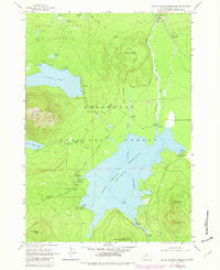
~ Crane Prairie Reservoir OR topo map, 1:24000 scale, 7.5 X 7.5 Minute, Historical, 1963, updated 1981
Crane Prairie Reservoir, Oregon, USGS topographic map dated 1963.
Includes geographic coordinates (latitude and longitude). This topographic map is suitable for hiking, camping, and exploring, or framing it as a wall map.
Printed on-demand using high resolution imagery, on heavy weight and acid free paper, or alternatively on a variety of synthetic materials.
Topos available on paper, Waterproof, Poly, or Tyvek. Usually shipping rolled, unless combined with other folded maps in one order.
- Product Number: USGS-5417642
- Free digital map download (high-resolution, GeoPDF): Crane Prairie Reservoir, Oregon (file size: 12 MB)
- Map Size: please refer to the dimensions of the GeoPDF map above
- Weight (paper map): ca. 55 grams
- Map Type: POD USGS Topographic Map
- Map Series: HTMC
- Map Verison: Historical
- Cell ID: 10589
- Scan ID: 279499
- Imprint Year: 1981
- Woodland Tint: Yes
- Visual Version Number: 2
- Photo Revision Year: 1981
- Aerial Photo Year: 1979
- Edit Year: 1981
- Field Check Year: 1963
- Datum: NAD27
- Map Projection: Polyconic
- Map published by United States Geological Survey
- Map Language: English
- Scanner Resolution: 600 dpi
- Map Cell Name: Crane Prairie Reservoir
- Grid size: 7.5 X 7.5 Minute
- Date on map: 1963
- Map Scale: 1:24000
- Geographical region: Oregon, United States
Neighboring Maps:
All neighboring USGS topo maps are available for sale online at a variety of scales.
Spatial coverage:
Topo map Crane Prairie Reservoir, Oregon, covers the geographical area associated the following places:
- Snow Creek - Crane Prairie Resort - Cow Meadow Recreation Site - Crane Prairie Reservoir - Cultus Lake Boat Ramp - Rock Creek Recreation Site - Craine Prairie Resort Marina - Little Cultus Lake - Cultus Mountain - Little Cultus Lake Campground Boat Ramp - Crane Prairie - Deschutes Bridge Guard Station (historical) - Snow Creek Project Camp - Charlton Creek - Cultus Lake Resort Marina - Corral Swamp Trail - Browns Mountain Boat Ramp - Crane Prairie Dam - Rock Creek Campground Boat Ramp - Wuksi Butte - Osprey Point Recreation Site - Palanush Butte - Cultus Lake Recreation Site - Crane Prairie Recreation Site - Cultus Lake - Comma Lake - Cultus Lake Trail - Quinn River Boat Ramp - Deer Creek - Cultus Corral Horse Camp - Billy Quinn Grave - Shukash Butte - Hidden Spring - North Corral Lake - Cow Meadow Boat Ramp - Craine Prairie Reservoir Day Use Boat Ramp - Corral Swamp - Little Cultus Lake Recreation Site - Craine Prairie Campground Boat Ramp - Cultus Lake Resort - Osprey Point - Quinn River Recreation Site - Twins Crane Prairie Trail - Ketchketch Butte - Gales Landing - Cultus Cove Recreation Site - Bench Mark Butte - South Corral Lake - West Cultus Lake Recreation Site - Robideau Landing - Cultus Creek - Deschutes Bridge Recreation Site - Cultus River - Multiple Springs
- Map Area ID: AREA43.87543.75-121.875-121.75
- Northwest corner Lat/Long code: USGSNW43.875-121.875
- Northeast corner Lat/Long code: USGSNE43.875-121.75
- Southwest corner Lat/Long code: USGSSW43.75-121.875
- Southeast corner Lat/Long code: USGSSE43.75-121.75
- Northern map edge Latitude: 43.875
- Southern map edge Latitude: 43.75
- Western map edge Longitude: -121.875
- Eastern map edge Longitude: -121.75


