
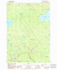
~ Cowhorn Mtn OR topo map, 1:24000 scale, 7.5 X 7.5 Minute, Historical, 1986, updated 1986
Cowhorn Mtn, Oregon, USGS topographic map dated 1986.
Includes geographic coordinates (latitude and longitude). This topographic map is suitable for hiking, camping, and exploring, or framing it as a wall map.
Printed on-demand using high resolution imagery, on heavy weight and acid free paper, or alternatively on a variety of synthetic materials.
Topos available on paper, Waterproof, Poly, or Tyvek. Usually shipping rolled, unless combined with other folded maps in one order.
- Product Number: USGS-5417580
- Free digital map download (high-resolution, GeoPDF): Cowhorn Mtn, Oregon (file size: 11 MB)
- Map Size: please refer to the dimensions of the GeoPDF map above
- Weight (paper map): ca. 55 grams
- Map Type: POD USGS Topographic Map
- Map Series: HTMC
- Map Verison: Historical
- Cell ID: 10462
- Scan ID: 279468
- Imprint Year: 1986
- Woodland Tint: Yes
- Aerial Photo Year: 1983
- Edit Year: 1986
- Field Check Year: 1984
- Datum: NAD27
- Map Projection: Lambert Conformal Conic
- Map published by United States Geological Survey
- Map Language: English
- Scanner Resolution: 600 dpi
- Map Cell Name: Cowhorn Mountain
- Grid size: 7.5 X 7.5 Minute
- Date on map: 1986
- Map Scale: 1:24000
- Geographical region: Oregon, United States
Neighboring Maps:
All neighboring USGS topo maps are available for sale online at a variety of scales.
Spatial coverage:
Topo map Cowhorn Mtn, Oregon, covers the geographical area associated the following places:
- Opal Lake - Tandy Bay - Tranquil Cove Recreation Site - Indigo Lake Recreation Site - Greenwood Point - Windy Lakes Trail - Bingham Lakes - Darlene Lake - Timpanogas Recreation Site - Cowhorn Creek - Crater Butte - Cornett Lake - Amos Lake - Whitefish Horse Camp - Indigo Lake - Timpanogas Lake - Meek Lake - Pinewan Lake - Bingham Meadow - Spring Campground Boat Ramp - Opal Lake Recreation Site - Snell Lake - Andy Lake - Windy Pass Way - Tandy Bay Recreation Site - Spring Forest Camp - Windy Group Camp - Windy Lakes - Tranquil Cove - Summit Lake - Summit Creek - Whitefish Creek - Suzanne Lake - Contorta Point - Cowhorn Mountain - Effie Lake - Mountain Creek - Farrell Lake - Nip and Tuck Lakes - Crescent Lake Recreation Site - Sawtooth Mountain - Contorta Point Recreation Site
- Map Area ID: AREA43.543.375-122.125-122
- Northwest corner Lat/Long code: USGSNW43.5-122.125
- Northeast corner Lat/Long code: USGSNE43.5-122
- Southwest corner Lat/Long code: USGSSW43.375-122.125
- Southeast corner Lat/Long code: USGSSE43.375-122
- Northern map edge Latitude: 43.5
- Southern map edge Latitude: 43.375
- Western map edge Longitude: -122.125
- Eastern map edge Longitude: -122


