
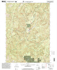
~ Chrome Ridge OR topo map, 1:24000 scale, 7.5 X 7.5 Minute, Historical, 1996, updated 1999
Chrome Ridge, Oregon, USGS topographic map dated 1996.
Includes geographic coordinates (latitude and longitude). This topographic map is suitable for hiking, camping, and exploring, or framing it as a wall map.
Printed on-demand using high resolution imagery, on heavy weight and acid free paper, or alternatively on a variety of synthetic materials.
Topos available on paper, Waterproof, Poly, or Tyvek. Usually shipping rolled, unless combined with other folded maps in one order.
- Product Number: USGS-5417364
- Free digital map download (high-resolution, GeoPDF): Chrome Ridge, Oregon (file size: 19 MB)
- Map Size: please refer to the dimensions of the GeoPDF map above
- Weight (paper map): ca. 55 grams
- Map Type: POD USGS Topographic Map
- Map Series: HTMC
- Map Verison: Historical
- Cell ID: 8691
- Scan ID: 279354
- Imprint Year: 1999
- Woodland Tint: Yes
- Aerial Photo Year: 1994
- Survey Year: 1996
- Datum: NAD27
- Map Projection: Lambert Conformal Conic
- Map published by United States Geological Survey
- Map published by United States Forest Service
- Map Language: English
- Scanner Resolution: 600 dpi
- Map Cell Name: Chrome Ridge
- Grid size: 7.5 X 7.5 Minute
- Date on map: 1996
- Map Scale: 1:24000
- Geographical region: Oregon, United States
Neighboring Maps:
All neighboring USGS topo maps are available for sale online at a variety of scales.
Spatial coverage:
Topo map Chrome Ridge, Oregon, covers the geographical area associated the following places:
- Onion Creek - Brushy Creek - Myers Creek - Lone Tree Pass - Briggs Valley - Swede Basin - Chrome Camp - Horse Mountain - Freeland Saddle - Sam Brown Horse Camp - Minnow Creek - Sam Brown Recreation Site - Freeland Mountain - Swede Creek - Elkhorn Mine - Windy Creek - Horse Creek - Wilderville Division - Myers Creek Recreation Site - Valley Creek - Dutchy Creek - Barr Mine - Lone Tree Creek - Lone Tree Ridge - Elkhorn Creek - Maple Creek - Whiskey Gulch - Big Pine Recreation Site - Granite Creek - South Fork Taylor Creek - Waterdog Creek - Taylor Mountain - Courier Mine - Chrome Ridge - Secret Valley - Secret Creek Recreation Site - Secret Creek
- Map Area ID: AREA42.542.375-123.75-123.625
- Northwest corner Lat/Long code: USGSNW42.5-123.75
- Northeast corner Lat/Long code: USGSNE42.5-123.625
- Southwest corner Lat/Long code: USGSSW42.375-123.75
- Southeast corner Lat/Long code: USGSSE42.375-123.625
- Northern map edge Latitude: 42.5
- Southern map edge Latitude: 42.375
- Western map edge Longitude: -123.75
- Eastern map edge Longitude: -123.625


