
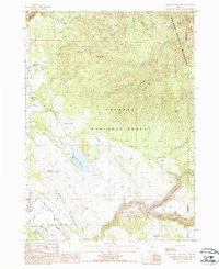
~ Campbell Reservoir OR topo map, 1:24000 scale, 7.5 X 7.5 Minute, Historical, 1988, updated 1988
Campbell Reservoir, Oregon, USGS topographic map dated 1988.
Includes geographic coordinates (latitude and longitude). This topographic map is suitable for hiking, camping, and exploring, or framing it as a wall map.
Printed on-demand using high resolution imagery, on heavy weight and acid free paper, or alternatively on a variety of synthetic materials.
Topos available on paper, Waterproof, Poly, or Tyvek. Usually shipping rolled, unless combined with other folded maps in one order.
- Product Number: USGS-5417166
- Free digital map download (high-resolution, GeoPDF): Campbell Reservoir, Oregon (file size: 13 MB)
- Map Size: please refer to the dimensions of the GeoPDF map above
- Weight (paper map): ca. 55 grams
- Map Type: POD USGS Topographic Map
- Map Series: HTMC
- Map Verison: Historical
- Cell ID: 6962
- Scan ID: 279249
- Imprint Year: 1988
- Woodland Tint: Yes
- Aerial Photo Year: 1983
- Edit Year: 1988
- Field Check Year: 1984
- Datum: NAD27
- Map Projection: Lambert Conformal Conic
- Provisional map: Yes
- Map published by United States Geological Survey
- Map Language: English
- Scanner Resolution: 600 dpi
- Map Cell Name: Campbell Reservoir
- Grid size: 7.5 X 7.5 Minute
- Date on map: 1988
- Map Scale: 1:24000
- Geographical region: Oregon, United States
Neighboring Maps:
All neighboring USGS topo maps are available for sale online at a variety of scales.
Spatial coverage:
Topo map Campbell Reservoir, Oregon, covers the geographical area associated the following places:
- Whisky Spring Trail - Rocky Flat - Anderson Field - Whisky Spring - Gayheart Slough - Paddock Camp - Keddy Field - Seven C Ranch - Campbell Dam - Swede Cabin - Buzz Spring - Butte Spring - Swing Field - Brownsworth Creek - Long Creek - Campbell Reservoir - Dutchman Flat - Paradise Creek - Boulder Spring - Deming Creek Trailhead - Hagerhorst Mountains - Boyd Spring - Swede Cabin Flat - Round Butte - Boulder Spring Trail - Yaden Flat - Gearhart Mountain
- Map Area ID: AREA42.542.375-121-120.875
- Northwest corner Lat/Long code: USGSNW42.5-121
- Northeast corner Lat/Long code: USGSNE42.5-120.875
- Southwest corner Lat/Long code: USGSSW42.375-121
- Southeast corner Lat/Long code: USGSSE42.375-120.875
- Northern map edge Latitude: 42.5
- Southern map edge Latitude: 42.375
- Western map edge Longitude: -121
- Eastern map edge Longitude: -120.875


