
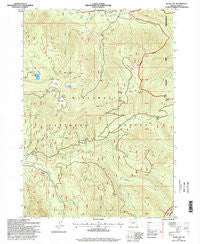
~ Blair Lake OR topo map, 1:24000 scale, 7.5 X 7.5 Minute, Historical, 1997, updated 1998
Blair Lake, Oregon, USGS topographic map dated 1997.
Includes geographic coordinates (latitude and longitude). This topographic map is suitable for hiking, camping, and exploring, or framing it as a wall map.
Printed on-demand using high resolution imagery, on heavy weight and acid free paper, or alternatively on a variety of synthetic materials.
Topos available on paper, Waterproof, Poly, or Tyvek. Usually shipping rolled, unless combined with other folded maps in one order.
- Product Number: USGS-5416796
- Free digital map download (high-resolution, GeoPDF): Blair Lake, Oregon (file size: 16 MB)
- Map Size: please refer to the dimensions of the GeoPDF map above
- Weight (paper map): ca. 55 grams
- Map Type: POD USGS Topographic Map
- Map Series: HTMC
- Map Verison: Historical
- Cell ID: 4302
- Scan ID: 279058
- Imprint Year: 1998
- Woodland Tint: Yes
- Aerial Photo Year: 1994
- Datum: NAD27
- Map Projection: Lambert Conformal Conic
- Map published by United States Geological Survey
- Map published by United States Forest Service
- Map Language: English
- Scanner Resolution: 600 dpi
- Map Cell Name: Blair Lake
- Grid size: 7.5 X 7.5 Minute
- Date on map: 1997
- Map Scale: 1:24000
- Geographical region: Oregon, United States
Neighboring Maps:
All neighboring USGS topo maps are available for sale online at a variety of scales.
Spatial coverage:
Topo map Blair Lake, Oregon, covers the geographical area associated the following places:
- Blair Meadows - Griffing Prairie - Curley Creek - Blair Lake Recreation Site - Fisher Creek - Blair Lake Trail - North Prairie - Spring Meadow - Alice Creek - Winnie Prairie - Salt Rock Prairie - Cayuse Creek - Salmon Creek Trail - Blair Lake - Spring Prairie - Beal Prairie - Mule Mountain - Long Prairie - Pitch Creek - Mule Mountain Lookout - Fisher Prairie - Delate Creek - Boomer Creek - Mule Creek - Captain Creek - Triangle Creek - Brock Creek - Furnish Creek - Etta Prairie - Ranger Creek - Devils Lake - Claire Prairie - Glade Creek - Koch Creek - Pocher Creek - Captain Prairie
- Map Area ID: AREA43.87543.75-122.25-122.125
- Northwest corner Lat/Long code: USGSNW43.875-122.25
- Northeast corner Lat/Long code: USGSNE43.875-122.125
- Southwest corner Lat/Long code: USGSSW43.75-122.25
- Southeast corner Lat/Long code: USGSSE43.75-122.125
- Northern map edge Latitude: 43.875
- Southern map edge Latitude: 43.75
- Western map edge Longitude: -122.25
- Eastern map edge Longitude: -122.125


