
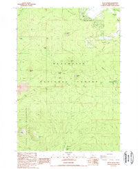
~ Black Crater OR topo map, 1:24000 scale, 7.5 X 7.5 Minute, Historical, 1988, updated 1988
Black Crater, Oregon, USGS topographic map dated 1988.
Includes geographic coordinates (latitude and longitude). This topographic map is suitable for hiking, camping, and exploring, or framing it as a wall map.
Printed on-demand using high resolution imagery, on heavy weight and acid free paper, or alternatively on a variety of synthetic materials.
Topos available on paper, Waterproof, Poly, or Tyvek. Usually shipping rolled, unless combined with other folded maps in one order.
- Product Number: USGS-5416784
- Free digital map download (high-resolution, GeoPDF): Black Crater, Oregon (file size: 13 MB)
- Map Size: please refer to the dimensions of the GeoPDF map above
- Weight (paper map): ca. 55 grams
- Map Type: POD USGS Topographic Map
- Map Series: HTMC
- Map Verison: Historical
- Cell ID: 72282
- Scan ID: 279054
- Imprint Year: 1988
- Woodland Tint: Yes
- Aerial Photo Year: 1957
- Edit Year: 1988
- Field Check Year: 1985
- Datum: NAD27
- Map Projection: Lambert Conformal Conic
- Provisional map: Yes
- Map published by United States Geological Survey
- Map Language: English
- Scanner Resolution: 600 dpi
- Map Cell Name: Black Crater
- Grid size: 7.5 X 7.5 Minute
- Date on map: 1988
- Map Scale: 1:24000
- Geographical region: Oregon, United States
Neighboring Maps:
All neighboring USGS topo maps are available for sale online at a variety of scales.
Spatial coverage:
Topo map Black Crater, Oregon, covers the geographical area associated the following places:
- Latta Crater - Graham Butte - Fivemile Butte - Dry Creek - Bluegrass Butte - Nootnagle Reservoir - Little Butte - Fourmile Spring - Cold Spring - Pole Creek Spring - Paulina Spring - Big Meadow Golf Course - Fourmile Butte - Cold Spring Recreation Site - Whispering Pine Horse Camp - Black Butte Ranch Rural Fire Protection District - Black Butte Ranch Census Designated Place - Black Crater Lake - Black Butte Swamp - Glaze Meadow - Graham Corral Horse Camp - Trout Creek - Glaze Meadow Golf Course - Sixmile Butte - Sisters Horse Camp (historical) - Nootnagle Dam
- Map Area ID: AREA44.37544.25-121.75-121.625
- Northwest corner Lat/Long code: USGSNW44.375-121.75
- Northeast corner Lat/Long code: USGSNE44.375-121.625
- Southwest corner Lat/Long code: USGSSW44.25-121.75
- Southeast corner Lat/Long code: USGSSE44.25-121.625
- Northern map edge Latitude: 44.375
- Southern map edge Latitude: 44.25
- Western map edge Longitude: -121.75
- Eastern map edge Longitude: -121.625


