
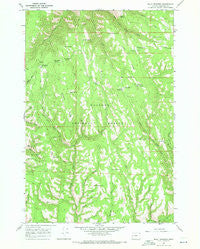
~ Billy Meadows OR topo map, 1:24000 scale, 7.5 X 7.5 Minute, Historical, 1967, updated 1971
Billy Meadows, Oregon, USGS topographic map dated 1967.
Includes geographic coordinates (latitude and longitude). This topographic map is suitable for hiking, camping, and exploring, or framing it as a wall map.
Printed on-demand using high resolution imagery, on heavy weight and acid free paper, or alternatively on a variety of synthetic materials.
Topos available on paper, Waterproof, Poly, or Tyvek. Usually shipping rolled, unless combined with other folded maps in one order.
- Product Number: USGS-5416746
- Free digital map download (high-resolution, GeoPDF): Billy Meadows, Oregon (file size: 12 MB)
- Map Size: please refer to the dimensions of the GeoPDF map above
- Weight (paper map): ca. 55 grams
- Map Type: POD USGS Topographic Map
- Map Series: HTMC
- Map Verison: Historical
- Cell ID: 3936
- Scan ID: 279042
- Imprint Year: 1971
- Woodland Tint: Yes
- Aerial Photo Year: 1966
- Field Check Year: 1967
- Datum: NAD27
- Map Projection: Polyconic
- Map published by United States Geological Survey
- Map Language: English
- Scanner Resolution: 600 dpi
- Map Cell Name: Billy Meadows
- Grid size: 7.5 X 7.5 Minute
- Date on map: 1967
- Map Scale: 1:24000
- Geographical region: Oregon, United States
Neighboring Maps:
All neighboring USGS topo maps are available for sale online at a variety of scales.
Spatial coverage:
Topo map Billy Meadows, Oregon, covers the geographical area associated the following places:
- Bear Spring - Aspen Spring - French Gulch - Hollow Log Spring - Bed Spring - Alder Spring - Hay Pen Camp - Poker Bill Spring - Elk Spring - Lone Spring - Trough Spring - McCarty Reservoir - Telephone Gulch - Warnock Spring - West Fork Peavine Creek - Getchel Meadows - Billy Meadows Guard Station - East Fork Peavine Creek - Volstead Reservoir - Hinton Spring - Teepee Spring - Getchel Ridge - Dougherty Recreation Site - Dougherty Spring - Baldwin Spring - East Fork Broady Creek - Coyote Spring - Yew Wood Spring - Snow Spring - Hollow Log Cow Camp - Quirk Spring - Long Ridge - Coyote Recreation Site - Billy Meadows - Paris Spring - Kernan Spring - Long Ridge Spring - Ellis Canyon - Red Hill Recreation Site - Red Hill
- Map Area ID: AREA45.87545.75-117.125-117
- Northwest corner Lat/Long code: USGSNW45.875-117.125
- Northeast corner Lat/Long code: USGSNE45.875-117
- Southwest corner Lat/Long code: USGSSW45.75-117.125
- Southeast corner Lat/Long code: USGSSE45.75-117
- Northern map edge Latitude: 45.875
- Southern map edge Latitude: 45.75
- Western map edge Longitude: -117.125
- Eastern map edge Longitude: -117


