
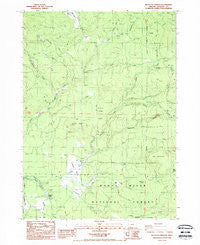
~ Big Butte Springs OR topo map, 1:24000 scale, 7.5 X 7.5 Minute, Historical, 1988, updated 1988
Big Butte Springs, Oregon, USGS topographic map dated 1988.
Includes geographic coordinates (latitude and longitude). This topographic map is suitable for hiking, camping, and exploring, or framing it as a wall map.
Printed on-demand using high resolution imagery, on heavy weight and acid free paper, or alternatively on a variety of synthetic materials.
Topos available on paper, Waterproof, Poly, or Tyvek. Usually shipping rolled, unless combined with other folded maps in one order.
- Product Number: USGS-5416690
- Free digital map download (high-resolution, GeoPDF): Big Butte Springs, Oregon (file size: 14 MB)
- Map Size: please refer to the dimensions of the GeoPDF map above
- Weight (paper map): ca. 55 grams
- Map Type: POD USGS Topographic Map
- Map Series: HTMC
- Map Verison: Historical
- Cell ID: 3661
- Scan ID: 279011
- Imprint Year: 1988
- Woodland Tint: Yes
- Aerial Photo Year: 1983
- Edit Year: 1988
- Field Check Year: 1985
- Datum: NAD27
- Map Projection: Lambert Conformal Conic
- Map published by United States Geological Survey
- Map Language: English
- Scanner Resolution: 600 dpi
- Map Cell Name: Big Butte Springs
- Grid size: 7.5 X 7.5 Minute
- Date on map: 1988
- Map Scale: 1:24000
- Geographical region: Oregon, United States
Neighboring Maps:
All neighboring USGS topo maps are available for sale online at a variety of scales.
Spatial coverage:
Topo map Big Butte Springs, Oregon, covers the geographical area associated the following places:
- Clarks Fork Creek - Parker (historical) - Rancheria Prairie - Timberline Creek - Fourbit Ford - Ash Creek - Carlson Camp - Rancheria Creek - Big Butte Springs - Clement Ranch - Cook Ranch - Goss Ranch - Blue Cow Spring - Oak Mountain - Fireline Creek - Camp Creek - Fourbit Ford Recreation Site - Horseshoe Creek - Lemont Post Office (historical) - Doug Ingram Tree - Deception Creek - South Fork Clarks Fork Creek - Oden Ranch - Twincheria Creek - Mount Pitt School - Mud Spring - Fourbit Creek - Hoffman Ranch - East Fork Ash Creek - Mule Creek - West Fork Ash Creek - Northern Glades - Grouse Ridge - Titanic Creek - North Fork Clarks Fork Creek - Phillips Creek - Jackass Creek - Merle Burn - Rancheria Ranch - Willow Creek - Camp Four - Thomson Ranch - Cedar Springs Creek - Friese Creek
- Map Area ID: AREA42.62542.5-122.5-122.375
- Northwest corner Lat/Long code: USGSNW42.625-122.5
- Northeast corner Lat/Long code: USGSNE42.625-122.375
- Southwest corner Lat/Long code: USGSSW42.5-122.5
- Southeast corner Lat/Long code: USGSSE42.5-122.375
- Northern map edge Latitude: 42.625
- Southern map edge Latitude: 42.5
- Western map edge Longitude: -122.5
- Eastern map edge Longitude: -122.375


