
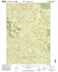
~ Bearbones Mountain OR topo map, 1:24000 scale, 7.5 X 7.5 Minute, Historical, 1997, updated 1999
Bearbones Mountain, Oregon, USGS topographic map dated 1997.
Includes geographic coordinates (latitude and longitude). This topographic map is suitable for hiking, camping, and exploring, or framing it as a wall map.
Printed on-demand using high resolution imagery, on heavy weight and acid free paper, or alternatively on a variety of synthetic materials.
Topos available on paper, Waterproof, Poly, or Tyvek. Usually shipping rolled, unless combined with other folded maps in one order.
- Product Number: USGS-5416596
- Free digital map download (high-resolution, GeoPDF): Bearbones Mountain, Oregon (file size: 19 MB)
- Map Size: please refer to the dimensions of the GeoPDF map above
- Weight (paper map): ca. 55 grams
- Map Type: POD USGS Topographic Map
- Map Series: HTMC
- Map Verison: Historical
- Cell ID: 2858
- Scan ID: 278962
- Imprint Year: 1999
- Woodland Tint: Yes
- Aerial Photo Year: 1997
- Edit Year: 1997
- Datum: NAD27
- Map Projection: Lambert Conformal Conic
- Map published by United States Geological Survey
- Map published by United States Forest Service
- Map Language: English
- Scanner Resolution: 600 dpi
- Map Cell Name: Bearbones Mountain
- Grid size: 7.5 X 7.5 Minute
- Date on map: 1997
- Map Scale: 1:24000
- Geographical region: Oregon, United States
Neighboring Maps:
All neighboring USGS topo maps are available for sale online at a variety of scales.
Spatial coverage:
Topo map Bearbones Mountain, Oregon, covers the geographical area associated the following places:
- Hobart Creek - Helena Saddle - Champion Post Office (historical) - Noonday Ridge - Bearbones Mountain - Helena Mine - Prospect Creek - Grizzly Mountain - Grouse Mountain Falls - Johnson Meadows Trail - Steamboat Trail - Windfall Lake - Windy Creek - Grass Mountain - Johnson Meadows - Saint Peter Creek - Rocky Point - Calapooya Way - Annie Creek - Gertrude Shelter - East Fork Steamboat Creek - Knott Creek - Knott Spring - Noonday Mine - Horse Heaven Creek - Grouse Mountain - Skeeter Camp Trail - Colorado Mine - Gertrude Lake - Frog Rock - Skeeter Camp - Mayflower Trail - Mayflower Mine - Grass Creek
- Map Area ID: AREA43.62543.5-122.625-122.5
- Northwest corner Lat/Long code: USGSNW43.625-122.625
- Northeast corner Lat/Long code: USGSNE43.625-122.5
- Southwest corner Lat/Long code: USGSSW43.5-122.625
- Southeast corner Lat/Long code: USGSSE43.5-122.5
- Northern map edge Latitude: 43.625
- Southern map edge Latitude: 43.5
- Western map edge Longitude: -122.625
- Eastern map edge Longitude: -122.5


