
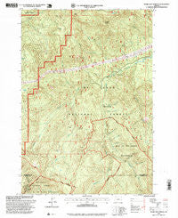
~ Bagby Hot Springs OR topo map, 1:24000 scale, 7.5 X 7.5 Minute, Historical, 1997, updated 1999
Bagby Hot Springs, Oregon, USGS topographic map dated 1997.
Includes geographic coordinates (latitude and longitude). This topographic map is suitable for hiking, camping, and exploring, or framing it as a wall map.
Printed on-demand using high resolution imagery, on heavy weight and acid free paper, or alternatively on a variety of synthetic materials.
Topos available on paper, Waterproof, Poly, or Tyvek. Usually shipping rolled, unless combined with other folded maps in one order.
- Product Number: USGS-5416502
- Free digital map download (high-resolution, GeoPDF): Bagby Hot Springs, Oregon (file size: 17 MB)
- Map Size: please refer to the dimensions of the GeoPDF map above
- Weight (paper map): ca. 55 grams
- Map Type: POD USGS Topographic Map
- Map Series: HTMC
- Map Verison: Historical
- Cell ID: 2112
- Scan ID: 278916
- Imprint Year: 1999
- Woodland Tint: Yes
- Aerial Photo Year: 1995
- Datum: NAD27
- Map Projection: Lambert Conformal Conic
- Map published by United States Geological Survey
- Map published by United States Forest Service
- Map Language: English
- Scanner Resolution: 600 dpi
- Map Cell Name: Bagby Hot Springs
- Grid size: 7.5 X 7.5 Minute
- Date on map: 1997
- Map Scale: 1:24000
- Geographical region: Oregon, United States
Neighboring Maps:
All neighboring USGS topo maps are available for sale online at a variety of scales.
Spatial coverage:
Topo map Bagby Hot Springs, Oregon, covers the geographical area associated the following places:
- Betty Creek - Peggy Creek - Ora Creek - Thunder Mountain - Pegleg Falls - Skookum Lake - Pansy Creek - Bagby Natural Research Area - Nohorn Trail - East Mountain Trail - Perry Creek - Joyce Lake - Hugh Creek Quarry - Bagby Hot Springs - Stroupe Creek Quarry - Molalla Trail - Pegleg Falls Recreation Site - Whetstone Creek - Bagby Hot Springs Guard Station - Hugh Creek - Skookum Lake Campground - Doris Creek - Nohorn Creek - Skin Creek - Rock Creek - Hughs Horse Gravel Pit - Baty Silver King Trail - Whetstone Trail - Opal Creek Wilderness - Stroupe Creek - Shower Creek - Lost Creek Meadow - Baty Butte - Spray Creek - South Fork Mountain Trail - Alice Creek - Pal Creek - Blister Creek - Pin Creek - Bagby Hot Springs Recreation Site
- Map Area ID: AREA4544.875-122.25-122.125
- Northwest corner Lat/Long code: USGSNW45-122.25
- Northeast corner Lat/Long code: USGSNE45-122.125
- Southwest corner Lat/Long code: USGSSW44.875-122.25
- Southeast corner Lat/Long code: USGSSE44.875-122.125
- Northern map edge Latitude: 45
- Southern map edge Latitude: 44.875
- Western map edge Longitude: -122.25
- Eastern map edge Longitude: -122.125


