
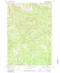
~ Arbuckle Mtn OR topo map, 1:24000 scale, 7.5 X 7.5 Minute, Historical, 1969, updated 1984
Arbuckle Mtn, Oregon, USGS topographic map dated 1969.
Includes geographic coordinates (latitude and longitude). This topographic map is suitable for hiking, camping, and exploring, or framing it as a wall map.
Printed on-demand using high resolution imagery, on heavy weight and acid free paper, or alternatively on a variety of synthetic materials.
Topos available on paper, Waterproof, Poly, or Tyvek. Usually shipping rolled, unless combined with other folded maps in one order.
- Product Number: USGS-5416424
- Free digital map download (high-resolution, GeoPDF): Arbuckle Mtn, Oregon (file size: 16 MB)
- Map Size: please refer to the dimensions of the GeoPDF map above
- Weight (paper map): ca. 55 grams
- Map Type: POD USGS Topographic Map
- Map Series: HTMC
- Map Verison: Historical
- Cell ID: 1322
- Scan ID: 278876
- Imprint Year: 1984
- Woodland Tint: Yes
- Photo Revision Year: 1983
- Aerial Photo Year: 1981
- Edit Year: 1983
- Field Check Year: 1981
- Datum: NAD27
- Map Projection: Lambert Conformal Conic
- Map published by United States Geological Survey
- Map Language: English
- Scanner Resolution: 600 dpi
- Map Cell Name: Arbuckle Mountain
- Grid size: 7.5 X 7.5 Minute
- Date on map: 1969
- Map Scale: 1:24000
- Geographical region: Oregon, United States
Neighboring Maps:
All neighboring USGS topo maps are available for sale online at a variety of scales.
Spatial coverage:
Topo map Arbuckle Mtn, Oregon, covers the geographical area associated the following places:
- Louse Spring - Black Mountain - Arbuckle Corral - Arbuckle Mountain - Coalmine Hill Recreation Site - Driveway Spring - Herren Creek - Sweet Grass Spring - Smith Ditch - Kelly Prairie - Horse Heaven Creek - Arbuckle Spring - Penland Prairie - Little Bald Mountain - Kelly Mountain - Linger Longer Prairie - Martin Prairie - Yokum Cabin - Coalmine Hill - Cutsforth County Park - Freezeout Ridge - Blakes Pond - Round Mountain - Bald Mountain - Wee Lambie Spring - Wilson Creek - Rasmuss Meadow - Martin Prairie Spring - Porcupine Ridge - Butcher Bill Meadow - Shaw Creek - Blake Ranch Spring - Herren Meadow - Cutsforth Pond
- Map Area ID: AREA45.2545.125-119.375-119.25
- Northwest corner Lat/Long code: USGSNW45.25-119.375
- Northeast corner Lat/Long code: USGSNE45.25-119.25
- Southwest corner Lat/Long code: USGSSW45.125-119.375
- Southeast corner Lat/Long code: USGSSE45.125-119.25
- Northern map edge Latitude: 45.25
- Southern map edge Latitude: 45.125
- Western map edge Longitude: -119.375
- Eastern map edge Longitude: -119.25


