
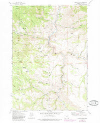
~ Aldrich Gulch OR topo map, 1:24000 scale, 7.5 X 7.5 Minute, Historical, 1972, updated 1985
Aldrich Gulch, Oregon, USGS topographic map dated 1972.
Includes geographic coordinates (latitude and longitude). This topographic map is suitable for hiking, camping, and exploring, or framing it as a wall map.
Printed on-demand using high resolution imagery, on heavy weight and acid free paper, or alternatively on a variety of synthetic materials.
Topos available on paper, Waterproof, Poly, or Tyvek. Usually shipping rolled, unless combined with other folded maps in one order.
- Product Number: USGS-5416294
- Free digital map download (high-resolution, GeoPDF): Aldrich Gulch, Oregon (file size: 14 MB)
- Map Size: please refer to the dimensions of the GeoPDF map above
- Weight (paper map): ca. 55 grams
- Map Type: POD USGS Topographic Map
- Map Series: HTMC
- Map Verison: Historical
- Cell ID: 481
- Scan ID: 278810
- Imprint Year: 1985
- Woodland Tint: Yes
- Photo Revision Year: 1985
- Aerial Photo Year: 1981
- Edit Year: 1985
- Field Check Year: 1972
- Datum: NAD27
- Map Projection: Lambert Conformal Conic
- Map published by United States Geological Survey
- Map Language: English
- Scanner Resolution: 600 dpi
- Map Cell Name: Aldrich Gulch
- Grid size: 7.5 X 7.5 Minute
- Date on map: 1972
- Map Scale: 1:24000
- Geographical region: Oregon, United States
Neighboring Maps:
All neighboring USGS topo maps are available for sale online at a variety of scales.
Spatial coverage:
Topo map Aldrich Gulch, Oregon, covers the geographical area associated the following places:
- Frazier Creek - Murderers Creek - Happy Reservoir - Black Canyon Creek - Ringsmeyer Reservoir - Rockpile Ranch - Dry Corner Spring - Payten Trail - Black Canyon - Placedor Gulch - Chickenhouse Gulch - Seven Sixty Spring - Payten Creek - North Corner Reservoir - Thicket Reservoir - Black Pine Creek - South Prong Black Canyon Creek - Dry Prong - Aldrich Gulch - Youngs Creek - Wind Creek - Elbow Gulch - Corner Creek - North Fork Wind Creek - Roop Spring - Wigwam Reservoir - Deadman Flat - Youngs Butte - Battle Creek Mountain - Lost Indian Trail - Big Spring - Cow Gulch - Lost Indian Reservoir - Soup Spring - Rock Pit Reservoir - Twin Stoves Creek - Pine Tree Campground - Doghouse Gulch - Jackass Creek - Jackass Mountain - Congleton Creek - Groundhog Knoll - Cameron Creek - Deer Gulch - Clark Spring - Black Canyon Ranch - Seven Sixty Reservoir - Martin Creek - Sundstrom Place (historical)
- Map Area ID: AREA44.37544.25-119.625-119.5
- Northwest corner Lat/Long code: USGSNW44.375-119.625
- Northeast corner Lat/Long code: USGSNE44.375-119.5
- Southwest corner Lat/Long code: USGSSW44.25-119.625
- Southeast corner Lat/Long code: USGSSE44.25-119.5
- Northern map edge Latitude: 44.375
- Southern map edge Latitude: 44.25
- Western map edge Longitude: -119.625
- Eastern map edge Longitude: -119.5


